NAIDOC Week 2020 will be celebrated 8-15 November due to the impact of COVID-19. This year's theme Always Was, Always Will Be recognises that First Nations people have occupied and cared for this continent for over 65,000 years.
2020 National NAIDOC logo.
This year's theme highlights the ongoing spiritual and cultural connection to land and the intimate knowledge of country. Within the State Library's Indigenous Languages Project, this knowledge is exemplified through language and how country is described. This blog post will explore some of the ways Aboriginal and Torres Strait Islander languages describe country, particularly everyday reminders such as placenames. Many landmarks have a Creation story in their origins, depicting the journey of an ancestral spirit such as the Rainbow Serpent who shaped the landscape.
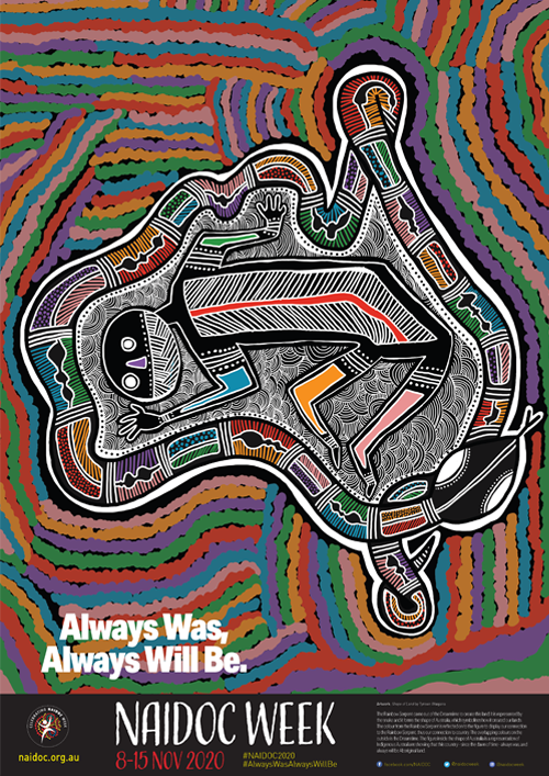
2020 National NAIDOC Poster.
The 2020 National NAIDOC Poster, Shape of Land, was designed by Tyrown Waigana, a Noongar and Saibai Islander man - the following text from the NAIDOC Week website provides the meaning and background story to the artwork.
Tyrown’s artwork tells the story of how the Rainbow Serpent came out of the Dreamtime to create this land. It is represented by the snake and it forms the shape of Australia, which symbolises how it created our lands. The colour from the Rainbow Serpent is reflected on to the figure to display our connection to the Rainbow Serpent, thus our connection to country. The overlapping colours on the outside is the Dreamtime. The figure inside the shape of Australia is a representation of Indigenous Australians showing that this country - since the dawn of time - Always Was, Always Will Be Aboriginal Land.
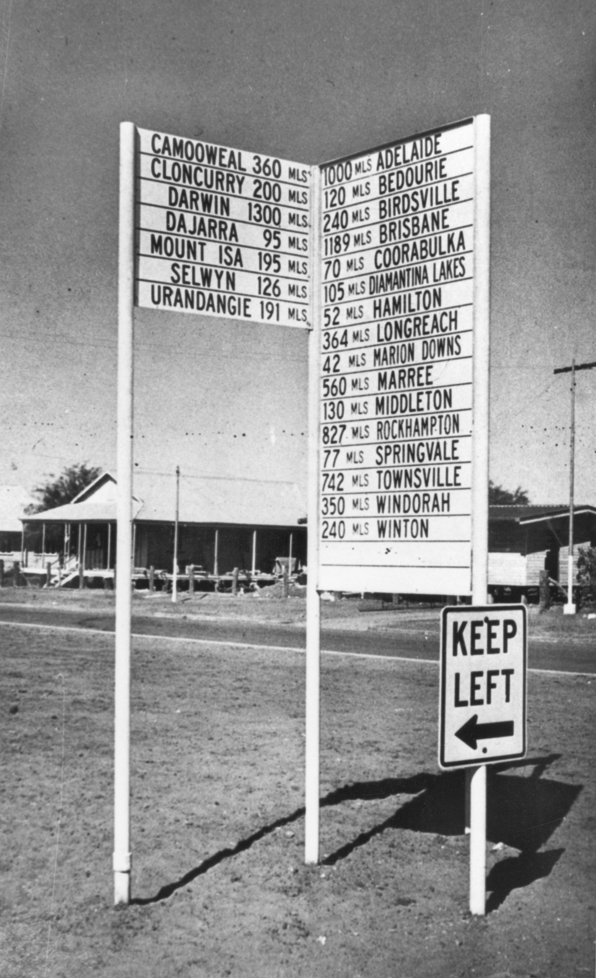
Road sign showing the distance to other locations from Boulia. JOL Negative Number 201070.
Today, while the story may be lost, the placename is often the only obvious reminder of the connection to country. Generally the traditional name has been 'anglicised' as shown in the above image of a road sign showing distances from the Western Queensland town of Boulia. While the sign is located in Pitta Pitta country, the placenames on the sign are drawn from a number of languages in the region:
- Camooweal is from an unknown/unrecorded language meaning 'a strong wind'.
- Cloncurry, while sounding Aboriginal was named by Burke after a friend Lady Cloncurry from Ireland
- Dajarra is from an unrecorded language believed to mean 'an isolated mountain'.
- Urandangie (also known as Urandangi) is reportedly a corruption of Aboriginal words uranda-ngie, language and dialect unknown, indicating 'much gidyea'.
- Bedourie means 'dust storm', again in an unrecorded language, possibly one of the local dialects.
- Coorabulka - while attributed to an Aboriginal language, there are no details on meaning or origins.
- Marree in South Australia is believed to be a corruption of a Dhirari word referring to place of possums and the site of an ancestral journey.
- Windorah is an example of uncertainty of the original meaning - it is listed as referring to a freshwater bream or a catfish.
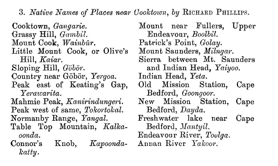
'Native names of places near Cooktown', Phillips (1898).
Placenames were documented very early by a range of individuals, including pastoralists, missionaries, anthropologists and others who had interactions with Aboriginal and Torres Strait Islander people. For example, the image above shows a selection of placenames in the Cooktown region by Phillips in 1898 - this list of placenames was an appendix to an article "Vocabulary of Australian Aborigines in the Neighbourhood of Cooktown, North Queensland". There is a growing recognition of traditional placenames existing prior to English names; the wordle below shows a short selection of the hundreds of placenames from across Queensland with Aboriginal origins or meanings.
Wordle showing selection of Aboriginal placenames.
It should be acknowledged that placenames, while a contemporary concept, held different interpretations by Aboriginal and Torres Strait Islander people. Rather than a single name for a river, there would be several names for the different bends, stretches of the watercourse. In the Torres Strait, the image below from the Haddon/Cambridge collection is of Mer Island, depicting the traditional Meriam names for numerous features on the island such as bays, rivers,mountains, etc.
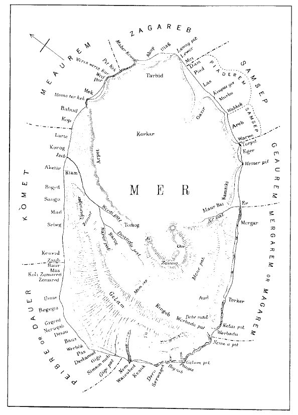
Sketch map of the island of Mer, Haddon (1908).
This NAIDOC Week, State Library encourages you to find out more about Aboriginal and Torres Strait Islander connection to country and the rich diversity of placenames across the landscape. There is a range of activities planned for the week including panels, discussions, culture quest, Black Diggers webinar, etc. - visit the What's On webpage for further details!
Additional material for this blog post was sourced from the National NAIDOC website; there is a range of resources including posters, teacher guides and other materials for schools and community groups to participate in NAIDOC Week 2020.
Desmond Crump
Indigenous Languages Coordinator, State Library of Queensland
State Library of Queensland Aboriginal and Torres Strait Islander Languages Webpages
State Library of Queensland Aboriginal and Torres Strait Islander Languages Map
Spoken: Celebrating Queensland languages exhibition
Jarjum Stories exhibition
Old Words, New Ways upcoming exhibition
Minya Birran: What next for Indigenous Languages?
Images
Cover image: Aboriginal land rights march in Brisbane, Queensland, 1982. State Library Image number: 30298-0001-0007
2020 National NAIDOC Logo from NAIDOC website.
2020 National NAIDOC Poster from NAIDOC website.
Road sign showing the distance to other locations from Boulia. Negative number: 201070.
Phillips, R. (1898) "Vocabulary of Australian Aborigines in the Neighbourhood of Cooktown, North Queensland".
Wordle - selection of Aboriginal placenames of Queensland.
Sketch map of the island of Mer, Haddon (1908).
References and Further Reading
State Library of Queensland has a range of materials relating to Aboriginal and Torres Strait Islander placenames, landmarks as well as Creation Stories highlighting connection to country - a selection is shown below; use One Search to find more items.
Brisbane History Group (1990) Brisbane: local, oral and placename history. Brisbane History Group: Brisbane. G 994.31 1990
Dixon, R. M. W. (1991) Words of our country: stories, place names and vocabulary in Yidiny, the Aboriginal language of the Cairns-Yarrabah region. G 499.15 1991
Eseli, P. (1998) Eseli’s Notebook. S 306.089 001
Helon, G. (1994) The Goreng Goreng tribe of South-East Queensland: its’ traditional tribal territory, clan divisions and proper names. (Map) Gurang Land Council: Bundaberg. MAPS 840 1998 02000 F
Hercus, L.; Hodges, F and Simpson, J. (2002) The land is a map: placenames of Indigenous origin in Australia. Q 919.4003 LAN
Hodes, J. (1998) Far North Queensland place & street names : their origins & meanings. REFJ 910.014 hod
Lamington Natural History Society (199?) Place names in Lamington National Park. VF 910.3 pla
Lawrie, M. The Margaret Lawrie Collection of Torres Straits Materials. TR2082
OM64-17 Archibald Meston Papers
Milne, R. (1993) Dahs and bahs: Aboriginal Placenames of Southern Queensland. Q 910.014 MIL
Phillips, R. (1898) "Vocabulary of Australian Aborigines in the Neighbourhood of Cooktown, North Queensland". In The Journal of the Anthropological Institute of Great Britain and Ireland, Vol. 27(1898), pp. 144-147. Online access via One Search.
Queensland Place Names Board (1963) Interim Gazetteer of Queensland Place Names. REF 919.43 1963
Queeensland Place Names Board (19-) Aboriginal place names, words and meanings collected at 'Terrick Terrick', Blackall, Central Queensland, about 1886. VF 919.43003 que
Sharp, N. (1993) Stars of Tagai. J 994.38 SHA
Simpson, J. (1975) Placenames of Southern Queensland. P 910.014 sim
Steele, J. G. (1984) Aboriginal Pathways in Southeast Queensland and the Richmond River. Q 994.3102 ste
Comments
Your email address will not be published.
We welcome relevant, respectful comments.