But where did they live?
By Katy Roberts, Library Technician, Information Services | 13 July 2020
Finding land holdings using electoral rolls and maps
Recently I was asked to find the land where a dairy farm was located on Ithaca Creek, Brisbane. The only information that I had was the landowner’s name, William Peter Gordon, and the fact that he married in Brisbane in 1869 and died in 1900.
A male landowner was entitled to vote in the late 19th Century, so I began searching the electoral rolls for Queensland in the 1890s. Queensland state electoral rolls 1860-1900 are held at State Library of Queensland on CD-ROM and microfilm, as well as being searchable on the Find My Past database.
Here is the relevant information from the electoral roll, showing land holdings for William Peter Gordon.
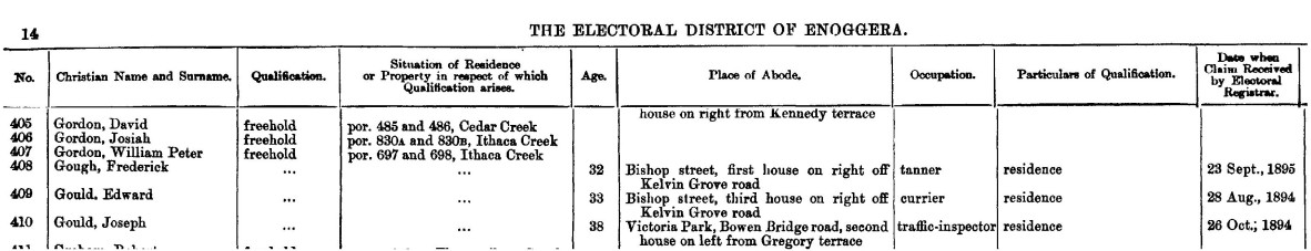
Queensland state electoral roll 1896.
Finding the land holdings
My next task was to find the land known as “por. [portion] 697 and 698, Ithaca Creek”.
Brisbane City Council Archives has digitised a map of Brisbane showing early land sales. The map was used to show sewerage lines and water and can be a bit tricky to search. Luckily Ithaca Creek was clearly marked, and I could scan along it to find Portions 697 and 698.
Here are Portions 697 and 698, owned by C. Tate. Ithaca Ck is marked at the top right of the map.
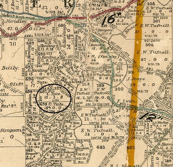
Brisbane Parish Map showing landowners, Metropolitan water supply and sewerage board, Brisbane, Map of the Board’s Water Supply Works, Brisbane City Council Archives.
How did W. P. Gordon become owner of land selected by C. Tate?
I knew that W. P. Gordon married Ann Tate, so I assumed that C. Tate would be a relative. A search of the historic death indexes on the Queensland registry for births, deaths and marriages website showed that Ann Gordon’s father was Charles Tate.
The 1943/ 1944 Refidex shows Gordon Road on the banks of Ithaca Creek. Eagle eyed readers will notice the postcode of Bardon was W4. They changed to the current 4 number system in 1967.
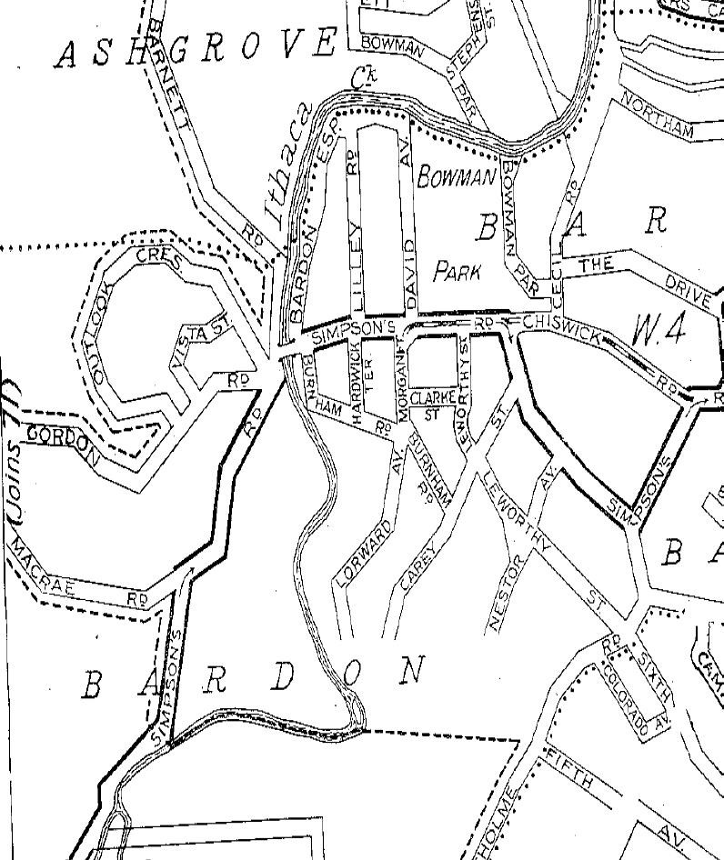
1943/1944 Refidex of Brisbane showing Gordon Road.
Finally, I used Google maps to check the area in 2020. And I discovered Gordon Road, Bardon, is still there.
Many streets all over Brisbane were named after prominent residents of the suburb, but I wonder how many of us know how their street was named?
References:
- Queensland Electoral Rolls can be used onsite at State Library – please talk to the friendly library staff at level 3 desk to locate these rolls as different years are in different formats.
- Brisbane City Council Archives: Metropolitan water supply and sewerage board, Brisbane - Map of the Board’s Water Supply Works can be found online at https://library-brisbane.ent.sirsidynix.net.au/client/en_AU/search/asset/24597/0
- Queensland Registry historic births, deaths, and marriages online index https://www.familyhistory.bdm.qld.gov.au/
- Refidex 1943 /44 (S919.431 021) can be requested from storage and viewed on Level 4. http://onesearch.slq.qld.gov.au/permalink/f/fhnkog/slq_alma21133577050002061
More information
House history checklist - /research-collections/family-history/house-history-checklist
Family history research guides - /research-collections/family-history/family-history-research-guides
Ask us - /plan-my-visit/services/ask-us
Comments
Your email address will not be published.
We welcome relevant, respectful comments.