The answer to the question asked last week - what is the suburb crossed by Norman Creek and home to historic residence Hatherton? - is Coorparoo.
The suburb of Coorparoo is believed to have been named by local residents at a meeting at Frederick Wecker's home on 22 March 1875 with those present resolving that the district as well as the newly established school should be named Coorparoo. The word was said to be the Aboriginal name for Norman Creek and the name was subsequently accepted by the Board of Education as the name of the proposed school.The original spelling was "Cooraparoo" but the shorter version was chosen and came into common usage.
An alternative name for the area was Steven's Town after Samuel Stevens who donated the land for the proposed school however this suggestion was rejected by Stevens himself.
The word "Coorparoo" is also said to be an Aboriginal word describing the sound of wild doves that were common in the area.
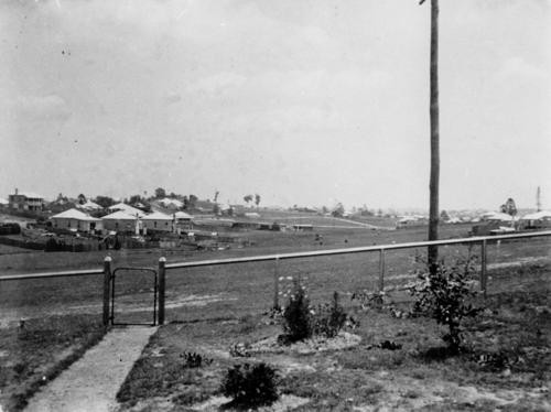
Coorparoo, 1914. Image no. 90836
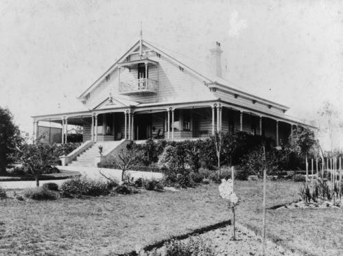
Eastleigh, Brentnall family home. Image no. 99713
Some early settlers and businesses included:
- Thomas Blackett Stephens (1856). By 1859 Stephens had established a wool scour on the banks of Ekibin Creek, near the present site of the Greenslopes Hospital. Stephens Road, South Brisbane is named in his honour. The present day Hanlon Park is on part of Stephen’s original holding.
- Gottlieb Klumpp (1858) purchased 15 acres of land facing the future Chatsworth Road. The Klumpp family's low set slab cottage was one of the earliest dwellings in the vicinity.
- Abraham James (1880s). James operated a large brick works situated in the vicinity of the present day St. Leonards Street.
- Thomas Brentnall (1884) who was a Methodist minister, journalist and later member of parliament. He purchased land in the vicinity of the present day Coorparoo Junction.
- Edward Deshon (1885) purchased land adjacent to the present Cavendish Road
- Reubin Nicklin
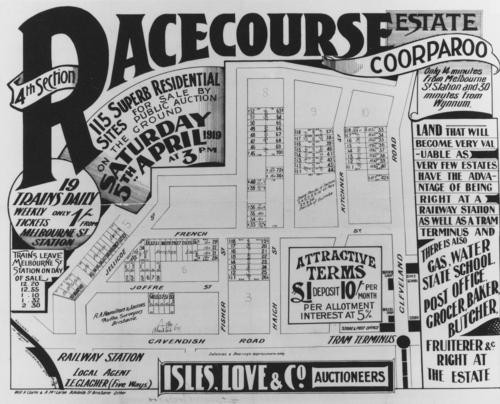
Racecourse Estate, Coorparoo, 1919 Image no. 186938
Some early housing estates included 1880 – St. Leonard’s Estate; Stanley Bridge Estate (1880), Cavendish Estate (1890) and the Racecourse Estate (1919).
Coorparoo has a range of distinctive homes, buildings and sites of interest, including:
- Spanish Mission Revival homes along Cavendish Road. This was a popular inter-war house style introduced from California.
- Ridgelands (1880s), built for the Blundell family
- Cardington (1880s) located at the corner of Norfolk Street and Cavendish Road. This residence was built by Thomas Howling who had purchased the allotments from early settler George Harden.
- Barston Place (1880), built for Scottish born James Burstall and named after his birthplace.
- Coorparoo Shire Hall (1892) located at the corner of Cavendish Road and Halstead Street. The building is now owned by the Coorparoo RSL Club and is now know as the Coorparoo School of Arts.
- Restored Tram Post located at the corner of Old Cleveland and Cavendish Roads.
- Hatherton (1886). This elite residence was built for Reubin Nicklin who previously residence was called Langlands. Reubin and his wife Jane were drowned in the “Quetta” disaster in 1890. The house has subsequently been extensively renovated and changed and is known as the “Queen Alexandra Home” having been used as a Methodist Home for children, teaching classrooms for the local TAFE College and more recently as a community centre.
- Chatsworth (1888), built for William Evans who worked at Stewarts of Stones Corner. Chatsworth Road is named after this residence.
- Langlands (1883), built for Reubin Nicklin. This building is located in the grounds of the present Villanova College and is the oldest surviving masonry residence in Coorparoo.
- Cavendish Road. The name of this road is said to have been derived as a result of the local residents’ preoccupation with card games. The book Cavendish on Whist was said to be often consulted as an authority.
- Roxy Cinema with seating for 1,200
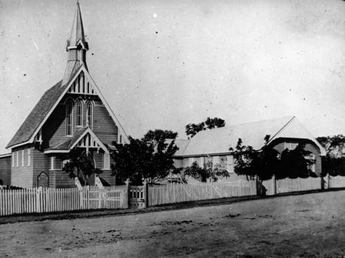
Coorparoo Methodist Church, ca. 1895 Image no. 172462
Some important dates in the history and development of Coorparoo include:
- 1856 – first bridge across Norman Creek constructed.
- 1876 – Coorparoo State School.
- 1876 – Frederick Robinson was operating a horse-drawn transport service from Coorparoo to Victoria Bridge.
- 1886 – Construction of the Stanley Street bridge.
- 1886 – Methodist Church located at the corner of Cavendish Road and York Street.
- 1888 – the Shire of Coorparoo is proclaimed, encompassing what is now the Coorparoo of today. Coorparoo originally included the present area of Stones Corner, Greenslopes and part of Holland Park.
- 1888 – the railway line extended through Coorparoo
- 1891 – Street lighting was first introduced. Later (1922) electricity was first used.
- 1893 – Floods had an adverse impact on the area. The access bridges were destroyed.
- 1913 (August) – St. James Catholic Church.
- 1922 (October) – Anglican Church
Comments
Your email address will not be published.
We welcome relevant, respectful comments.