200th anniversary of John Oxley's exploration of the Brisbane River (Maiwar): Day 3
By Anna Thurgood, Engagement Officer | 4 December 2023
In October 1823 John Oxley, Surveyor General for the colony of New South Wales, had been sent north to find a suitable site for a new penal settlement, one that could house the ‘worst of the worst’ re-offending convicts.
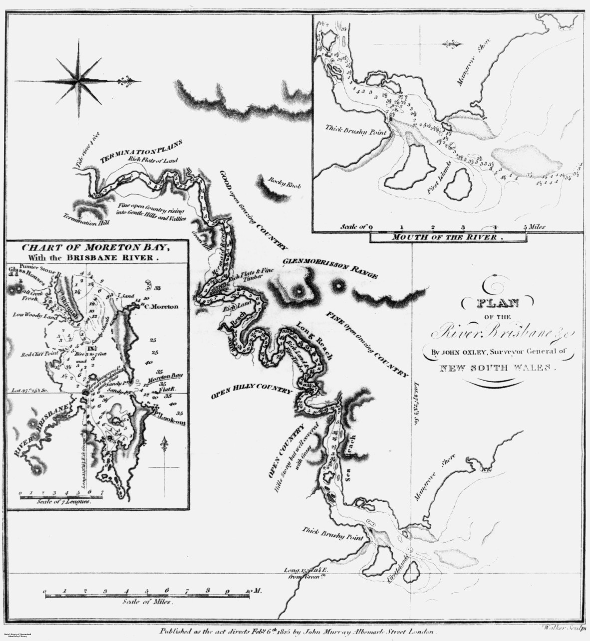
Plan of the River Brisbane and chart of Moreton Bay, as drawn by John Oxley, 1823. Negative no. 69012. John Oxley Library, State Library of Queensland.
Tasked with surveying and reporting back on three sites: Port Bowen; Port Curtis (Gladstone) and Moreton Bay, Oxley was returning from Port Curtis when he entered Moreton Bay in his government brig, the Mermaid, on 29 November 1823.
He immediately found two former convicts, Thomas Pamphlett and John Finnegan, on Bribie Island who had survived a shipwreck and been cared for by local Aboriginal people. While Oxley suspected a large river entered Moreton Bay, Pamphlett and Finnegan confirmed they had been there.
After a failed attempt to find this river in a small whale boat, where Finnegan accidentally showed Oxley the wrong river, the small party entered the much larger Brisbane River on 2 December1823.
Oxley’s field notebooks are quite brief, mainly about surveying the breadth and depth of the river, but he does describe what he sees around him. We also have his Report of an Expedition to survey Port Curtis, Moreton Bay and Port Bowen, which Oxley wrote and presented to Governor Brisbane in January 1824.
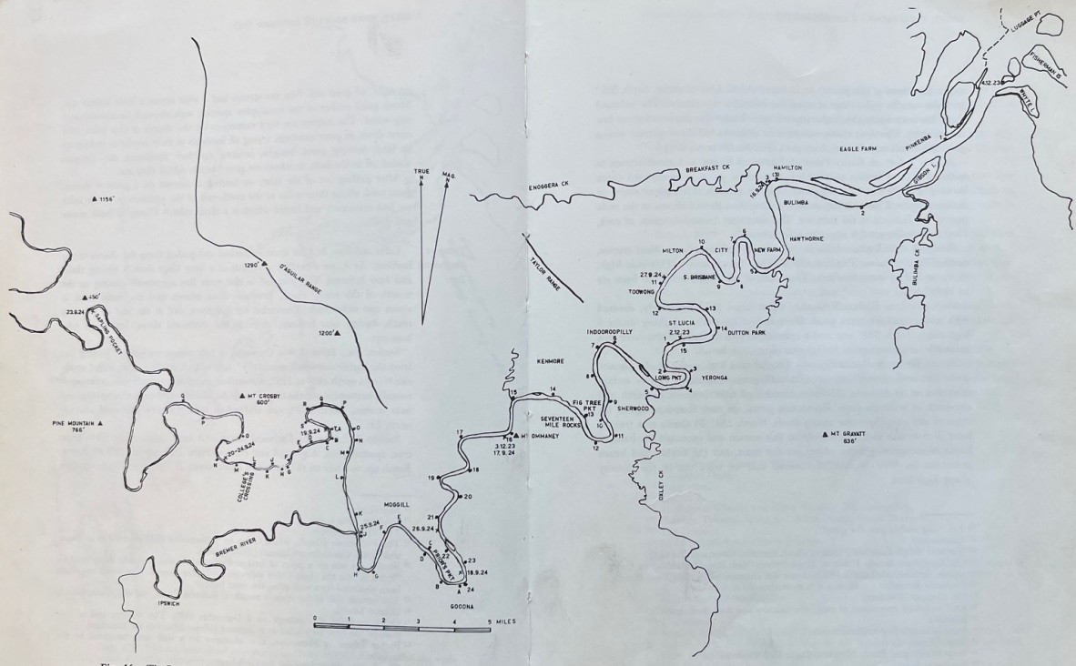
The Brisbane River according to modern surveys, showing Oxley’s routes in 1823 and 1824, figure 16 (p. 108-109), The Explorers of the Moreton Bay District 1770 – 1830, 1972, by J.G. Steele. Published by University of Queensland Press. Call no. Q 919.432042 STE C2. John Oxley Library, State Library of Queensland.
This is part of a series of blog articles covering John Oxley’s journey in Maiwar, the Brisbane River. On this day, 200 years ago, Oxley had travelled as far as Goodna and decided to turn back as they were running low on provisions. The party had begun journeying downstream and camped the night at ‘Green Hill’, now known as Mt Ommaney.
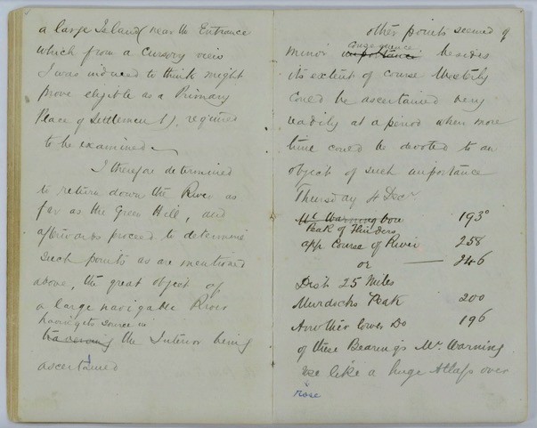
Extract from Field Book: Exploration of Brisbane River, 30 November 1823 – 5 December 1823. John Oxley (surveyor). Item ID: ITM291077. Queensland State Archives.
NOTE: Oxley's entry for Thursday 4 December 1823 begins halfway down the right page.
On the morning of Thursday 4 December 1823, Oxley first took bearings of points and landmarks around him. He had incorrectly identified Mt Warning, which he passed on his northward voyage. This mountain, a landmark to mariners since Cook’s days, was actually shielded from Oxley’s view by the MacPherson Range.
Oxley doesn’t write much about this day in his field notebook, as he had previously described the countryside on the upstream voyage, writing a couple of paragraphs focused on camping the night near the entrance to the river:
Of these bearings Mt Warning rose like a huge Atlas over the surrounding Country, the Range of which it is the Nucleus gradually losing itself to the West from Starboard. To North West we scarcely saw a hill and we could have seen any within 50 or 60 miles.
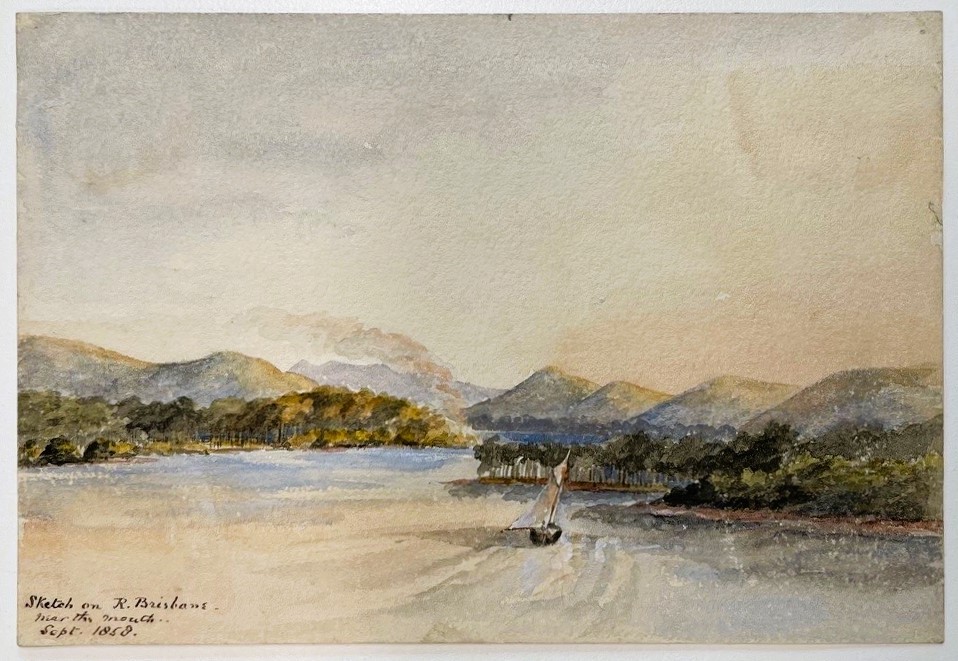
Sketch on River Brisbane, near the mouth, September 1858. TBH. Accession no. 30267 Thomas Biddulph Hutton watercolours. John Oxley Library, State Library of Queensland.
Descended the River, examined the Right Bank near the end of Sea Reach [now known as Hamilton and Quarries Reaches]. Fresh water and tolerable land – passed through between the Island, have 2 fathoms at low waters. Shortly deep to 3 ½ this Channel though narrow seems the Best, other channel may be found however as the River is very wide, it was dark when we got to the entrance of the River, we could not land on any part of the Mainland for Mangroves and mud banks. We were forced to take up our residence on a Mangrove Island covered by the Tide at Spring Tide, we had scarce pitched the Tents on this bank before we had a very heavy Storm of Wind and Rain with Thunder and Lightning which lasted about 2 hours, wetting us and added to the comforts of innumberable hosts of Musquitos [sic].
In his report to the Governor, Oxley wrote about this day:
…I stopped for the Night at the base of Green Hills, the highest of which was ascended the next morning and the view from it more extensive than I anticipated. The high coast range, of which Mt Warning is the nucleus, appeared gradually to lose itself westward and with the exception of the Peak before mentioned, and which appears to be the termination of the North extreme of the Mt Warning Range, there was scarcely an elevation above the ordinary level of the Country to be seen…
So much time was spent in the examination of the Country about Sea Reach that it was quite dark when we got to the entrance of the River, which, out of respect to His Excellency the Governor under whose orders this Bay was examined, was now honoured with the name of Brisbane River.
Following the wet and uncomfortable night spent on the island in the entrance to the river, John Oxley and his party managed to return to their ship anchored in the bay.
The next blog article will pick up the story of Oxley’s journey on the following day, Friday 5 December 1823, the final day of his voyage, locating and exploring the large river emptying into Moreton Bay.
Further resources:
Accession 33036 John Oxley papers. John Oxley Library, State Library of Queensland.
Report of an expedition to survey Port Curtis, Moreton Bay and Port Bowen: with a view to form convict penal settlements there, 1825. John Oxley. Call no. RBJ 994.3 OXL. John Oxley Library, State Library of Queensland.
Plan of the river Brisbane by John Oxley, Surveyor General of New South Wales, created 6 Feb. 1825. John Oxley; John Walker sculpt. Call no. RBM 841.15 1825 00265 E. John Oxley Library, State Library of Queensland.
The Explorers of the Moreton Bay District 1770 – 1830, 1972. J.G. Steele. Published by University of Queensland Press. Call no.Q919.432042 STE C2. John Oxley Library, State Library of Queensland.
Field Book: Exploration of Brisbane River, 30 November 1823 – 5 December 1823. John Oxley (surveyor). Item ID: ITM291077. Queensland State Archives.
Comments
Your email address will not be published.
We welcome relevant, respectful comments.