200th anniversary of John Oxley's exploration of the Brisbane River (Maiwar): Day 2
By Anna Thurgood, Engagement Officer | 3 December 2023
Users are advised that this material may contain culturally sensitive imagery and descriptions which may not normally be used in certain public or community contexts. Annotation and terminology which reflects the creator's attitude or that of the era in which the item was created may be considered inappropriate today. This material may also contain images, voices or names of deceased persons.
In October 1823 John Oxley, Surveyor General for the colony of New South Wales, had been sent north to find a suitable site for a new penal settlement, one that could house the ‘worst of the worst’ re-offending convicts.
Tasked with surveying and reporting back on three sites: Port Bowen; Port Curtis (Gladstone) and Moreton Bay, Oxley was returning from Port Curtis when he entered Moreton Bay in his government brig, the Mermaid, on 29 November 1823.
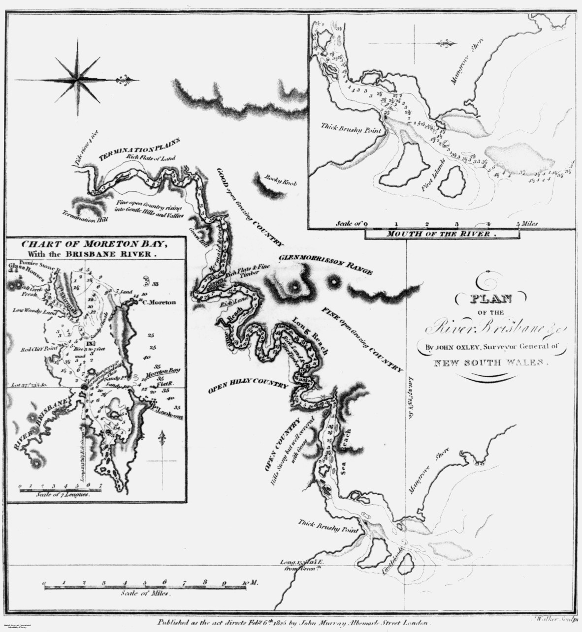
Plan of the River Brisbane and chart of Moreton Bay, as drawn by John Oxley, 1823. Negative no. 69012. John Oxley Library, State Library of Queensland.
Upon entering Moreton Bay he immediately found two former convicts, Thomas Pamphlett and John Finnegan, on Bribie Island who had survived a shipwreck and been cared for by local Aboriginal people. While Oxley suspected a large river entered Moreton Bay, Pamphlett and Finnegan confirmed they had been there.
After a failed attempt to find this river in a small whale boat, where Finnegan accidentally showed Oxley the wrong river, the small party entered the much larger Brisbane River on 2 December1823.
Oxley’s field note books are quite brief, mainly surveying the breadth and depth of the river, but they do describe what he sees around him. We also have his Report of an Expedition to survey Port Curtis, Moreton Bay and Port Bowen, which Oxley wrote and presented to Governor Brisbane in January 1824.
This is part of a series of blog articles covering John Oxley’s journey in Maiwar, the Brisbane River. On this day, 200 years ago, Oxley had travelled as far as Dutton Park / St Lucia and made camp for the night here.
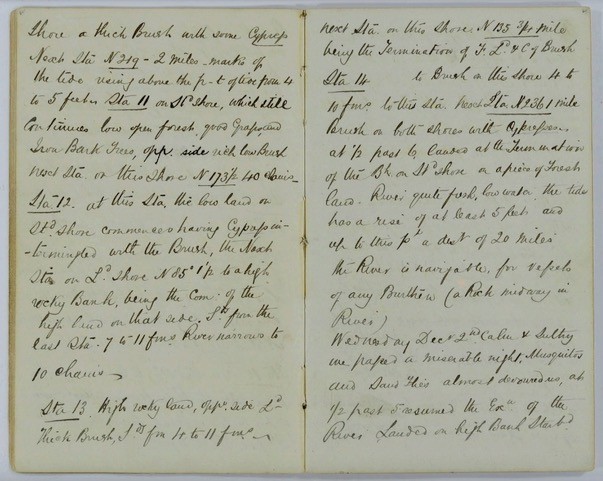
Extract from Field Book: Exploration of Brisbane River, 30 November 1823 – 5 December 1823. John Oxley (surveyor). Item ID: ITM291077. Queensland State Archives
NOTE: the right page shows Oxley's entry for Wednesday 3 December 1823, although he incorrectly labelled it the 2nd December.
The following morning Oxley wrote in his field notebook:
Wednesday Dec. 2nd [it was actually the 3rd]
Calm and sultry. We passed a miserable night, Musquitos [sic] and Sand Flies almost devoured us, at ½ past 5 resumed the Expedition of the River. Landed on high Bank, Starboard shore.
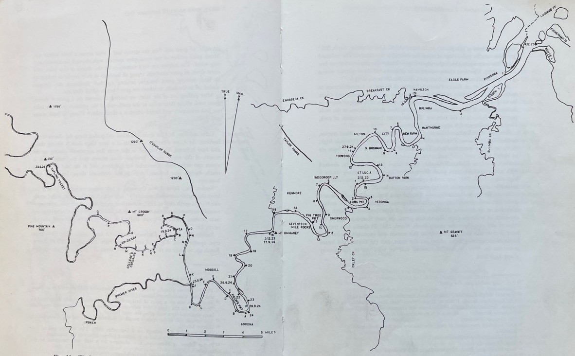
The Brisbane River according to modern surveys, showing Oxley’s routes in 1823 and 1824, figure 16 (p. 108-109), The Explorers of the Moreton Bay District 1770 – 1830, 1972, by J.G. Steele. Published by University of Queensland Press. Call no. Q 919.432042 STE C2. John Oxley Library, State Library of Queensland.
NOTE: this map, drawn correctly using modern surveys, charts Oxley's routes up the river in 1823 and 1824. The numbered 'stations' are referred to in his field note book from 1823, the lettered 'stations' are from his subsequent journey in 1824. Campsites are marked with a cross (X) and are dated.
Oxley resumes his survey, taking bearings and soundings at various points along the river, numbered on the map starting each new day again from 1 (noting that lettered stations refer to a later expedition). At station 2, located at Long Pocket where Indooroopilly Golf Course is situated, he writes:
Brush land, highest above the water about 15 to 20 feet. Opposite Brush Land… River ¼ mile wide and very noble reaches. Shores muddy, a large lagoon at this Station.
At station 4, probably close to where the Tennyson Power Station once stood, Oxley writes:
River about 30 chains wide, water very muddy. Rich Brush land on both sides… much Cypress [hoop pine] on Larboard side.
Landed and examined the Brush, it abounds with Noble Timber Specimens of Two New Species we procured, one a Piece of noble dimension, the other a Black heavy wood of great size, the soil uncommonly rich from 10, 15 to 30 feet above the River, no floods. We also discovered that the Tree which we had hitherto taken for Cypress is this new description of Pine from 100 to 140 feet high.
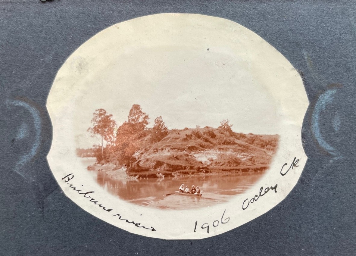
Oxley Creek, 1906. Photographer unknown. Accession no. APA-49 Views of Brisbane rivers and suburbs 1906 (page 15). John Oxley Library, State Library of Queensland.
At station 5 he writes:
At the Mouth of a smaller River which we called Canoe River, being the spot where Parsons and his companion found a Canoe in which they went down the River.
To the next Station, Forest land rising back 2 miles to a lofty ridge.
As the story goes, Finnegan and Pamphlett, who were being cared for by the local Turrbal people, had walked up the river they called Maiwar for around one month before they stole a canoe to travel back down the river and continue walking north. Sometime between July and October 1823, the two convicts made it to Bribie Island where they were again looked after by the local people. Although Oxley named this Canoe River, a later survey conducted by Edmund Lockyer named the tributary Oxleys Creek. Many years later, the Pamphlett Bridge was built over this creek.
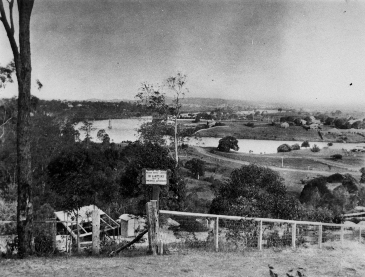
Early view of Indooroopilly taken from Finney’s Hill United Silver Mine, undated. Photographer unknown. Negative no. 80004. John Oxley Library, State Library of Queensland.
NOTE: the Albert Bridge, with its distinctive arches, is visible in the distance of this image. Built in 1894-185 to replace one lost in the 1893 flood, this heritage listed rail bridge still exists today.
As they continued on their journey upstream, Oxley wrote at station 6, located at the Indooroopilly end of the Walter Taylor Bridge:
At foot of High Brush. To Canoe River navigable for large ships, afterwards owing to the great Breadth of the River the Water shoaled to 2 fathoms at low water, but toward this Station deepened again to 5 and 6 fathoms. Starboard side Brush.
Saw 3 Natives evidently strangers to white people.
The next 4 station entries in Oxley’s field notebooks are very brief. At station 7 he mentions ‘mud, high land’; at station 8 he notes ‘Forest land’; at station 9 he mentions ‘rich land on both sides’; at station 10 he writes ‘Rocky Bank on Larboard side… this side Rich Brush’ and at station 11 he notes ‘High Bank this side between it and next Station which is high and Rocky, on same side is a Brush, Pine, etc.’
At station 12, located where the suburb of Oxley is now, he writes:
Low Brush, this side high and Rocks, then Brush to next Station… went to a Station on Starboard shore, crossing a Reef of Rocks [Seventeen Mile Rocks] having 2 fathoms on them then depth to 5 fathoms, the tide rushing over them like a Bar.
At station 14, the site of Kenmore / Chapel Hill, Oxley notes ‘Forest Land’ on Starboard side, then at station 15, where Moggill Creek enters the river, he writes:
Reaches fine and broad. Next Station to Base of sloping clear Hills on Larboard side.
At station 16, Oxley describes what we now call Mount Ommaney and records seeing Aboriginal people in the simplest terms:
Fine clear Hill then commences low, opposite side fine Rich forest land, small apple tree (Angofera [sic]). Next station… to Bar of Rocky Hill on Larboard shore, 2 ¼ miles – Natives.
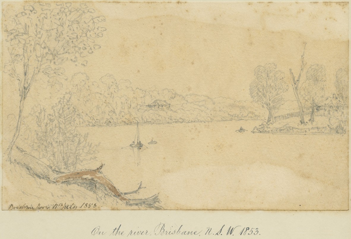
On the river, Brisbane, N.S.W., 11 July 1853. Sketch by Henry John Douglas Scott-Montagu (later Baron Montagu of Beaulieu). Item no. 3751/5. John Oxley Library, State Library of Queensland.
Station 17, where Pullenvale is now located, he describes:
Fine Forest land on both sides. Timber, chiefly Eucalyptus and apple Tree.
The ‘apple tree’ Oxley documents is a species of Angophora, actually a eucalyptus variety commonly called ‘smooth bark apple’.
At station 19, still in the Pullenvale/Moggill area, Oxley writes:
High flat Bank of Rich land… Ascended the Bank, the country very open and generally to be called quite level, the inequality being very slight, no high land in any quarter, the soil a rich Sandy loam, green and apple trees.
At station 21, he records:
River narrow. Brush on both sides, the Larboard shore the lowest, at end of the next Station [on same side of river] the land rises and is to that Station higher Brush land. Flood tide still continues, and Hills now of moderate elevation visible, nor anything resembling Rapids or denoting a Mountainous source, no sign whatsoever of Flood.
At station 22, in the area now known as Priors Pocket, Oxley describes his impressions of a beautiful landscape:
High flat of Rich land on this Starboard side, opposite side low and Brushy, rising to a Low Hill.
Great abundance of Kurrajong and various Climbing plants in full flower under the River. Scenery very beautiful. Passed an Island [Cockatoo Island], all on the River – a level country. Iron Bark Trees. Country good.
At the next station, on the Wacol side of the river, he writes of deciding to end his journey and prepare to return to the Mermaid moored in the bay. Oxley named the hill upon which he surveyed the surrounding countryside Termination Hill, later the site of Wolston Park Hospital at Goodna:
High hilly Brush, to the end of next Station [station 24] on Larboard side, then begins Brush. Opposite side low flat of rich land with very large Gum Trees, near the Water side…
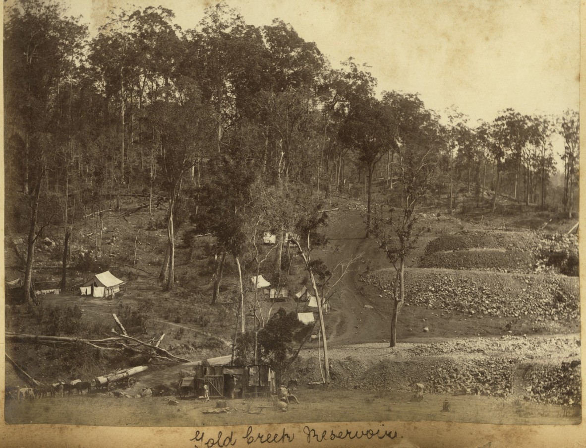
Construction of the Gold Creek Reservoir, undated. Photographer unknown. Image no. APO-026-0001-0030. John Oxley Library, State Library of Queensland.
NOTE: this image of the Gold Creek Reservoir at Upper Brookfield under construction (to supply the town of Brisbane with drinking water) is indicative of the type of country Oxley describes.
Landed on the Starboard shore, a Rich flat, the Flood tide being down above an hour and the Men extremely fatigued with rowing 8 hours under a Burning Sun… Every appearance indicates that the river may continue navigable to a great distance as we have hitherto come. It is remarkable that the tide here should nearly equal in height the Bay tide.
After taking refreshments landed on Larboard shore and ascended a small hill. Poor land, good timber… a distant Mountain which I take to be in the vicinity of Mt Warning, if not the Mountain itself.
…25 or 30 miles Round form this point to the N.W., I should consider the Country to decline in elevation rather than otherwise it appeared, in fact an immense extended Plain, of which no great portion was visible, the point of view being little elevated above the Country around, the hill might be a bank 120 feet above the water. The only hills of 6 or 800 feet in height were those we had passed to the Northward, this appearance of the Country from the slowness of the current and the depth of water induce me to conclude that the River will be found navigable for Vessels of Burden to a very considerable distance, probably at least 50 miles. I cannot help entertaining a strong belief that this is no River having its source in Mountain Streams. I see none to give them, on the contrary my opinion is strongly in favour of its deriving its source in an Interior Lake, which ever turns out to be the case, it is by far the largest River in New South Wales, and Promises to be of the utmost importance to the colony from the very fertile country it passes through affording the means of water communication with the Sea to a vast extent of Country, the great portion of which is capable of producing the richest productions in the Tropics.
Examined the country to the South East, a gently undulating Forest country, of good soil and Timber declining in low vallies [sic] towards the South, the Peak of a Mountain being the only elevated land in the direction from North East to South.
I had not contemplated such a discovery and was therefore totally unprovided with the means of ascertaining how much farther the River was navigable, we were about 70 miles from the Vessel and our provisions were only calculated for the present day, the entrance of the River was also to be sounded and its positions fixed, as also a large Island (near the Entrance which from a cursory view I was indeed to think might prove eligible as a Primary Place of settlement), requires to be examined.
I therefore determined to return down River as far as the Green Hill [Mt Ommaney], and afterwards proceed to determine such points as are mentioned above, the great object of a large navigable River have its source in the Interior being ascertained.
Other points seemed of minor consequence besides its extent of course Westerly could be ascertained very readily at a period when more time could be devoted to an object of such importance.
In Oxley's report to the Governor, he wrote of this day's journey - Wednesday 3 December 1823:
…the examination was resumed and with increased satisfaction we proceeded about 30 miles further, no diminution having taken place either in the breadth or depth of the River, except in one place, for the extent of about 30 yards, a ridge of detached rocks extending across, having nor more than 12 feet on them at high water. From this point to Termination Hill, the River continued of nearly uniform size, the country on either side of a Very Superior description and equally well adapted for cultivation or grazing, the timber abundant and fit for all the purposes of domestic use or exportation. The Pine trees, if they should prove of good quality, were of a Scantling [size] Sufficient for the topmasts of large Ships, some measured upwards of 30 inches in diameter, and from 50 to 80 feet without a branch.
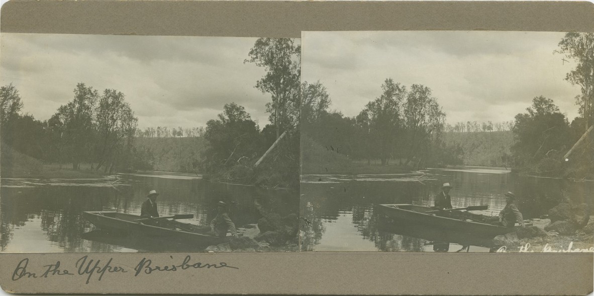
Boating on the Upper Brisbane River, Queensland, undated. Stereoscopic photograph. Photographer unknown. Image no. 7709-0001-0021. John Oxley Library, State Library of Queensland.
The Boat’s Crew were so exhausted by their continued exertions under a vertical sun, that I was reluctantly compelled to relinquish my intention of proceeding to the termination of Tidewater at this time… Having concluded upon terminating at this Point the examination of the River (being 70 miles from the Vessel and our Stock of provisions expended, not having anticipated such a discovery), I landed on the South Shore for the purpose of examining the surrounding Country… There was no appearance of the River being even occasionally flooded, no mark being found more than 7 feet above the level which is little more than would be caused by the Flood Tide at High Water forcing back any unusual accumulation of waters in Rainy Seasons.
Following this short break, Oxley and his crew turned around and began heading downstream, camping for the night at the base of ‘Green Hill’, now known as Mt Ommaney.
The next blog article will continue the story of Oxley’s journey, beginning on the following day, the morning of Thursday 4 December 1823, as he starts to realise the urgency of returning to his ship, the Mermaid, anchored in Moreton Bay, with energy and provisions running low.
Further resources
Accession 33036 John Oxley papers. John Oxley Library, State Library of Queensland.
Report of an expedition to survey Port Curtis, Moreton Bay and Port Bowen: with a view to form convict penal settlements there, 1825. John Oxley. Call no. RBJ 994.3 OXL. John Oxley Library, State Library of Queensland.
Plan of the river Brisbane by John Oxley, Surveyor General of New South Wales, created 6 Feb. 1825. John Oxley; John Walker sculpt. Call no. RBM 841.15 1825 00265 E. John Oxley Library, State Library of Queensland.
The Explorers of the Moreton Bay District 1770 – 1830, 1972. J.G. Steele. Published by University of Queensland Press. Call no.Q919.432042 STE C2. John Oxley Library, State Library of Queensland.
Field Book: Exploration of Brisbane River, 30 November 1823 – 5 December 1823. John Oxley (surveyor). Item ID: ITM291077. Queensland State Archives.
Comments
Your email address will not be published.
We welcome relevant, respectful comments.