200th anniversary of John Oxley's exploration of the Brisbane River (Maiwar): Day 1
By Anna Thurgood, Engagement Officer | 2 December 2023
Users are advised that this material may contain culturally sensitive imagery and descriptions which may not normally be used in certain public or community contexts. Annotation and terminology which reflects the creator's attitude or that of the era in which the item was created may be considered inappropriate today. This material may also contain images, voices or names of deceased persons.
In October 1823 John Oxley, Surveyor General for the colony of New South Wales, had been sent north to find a suitable site for a new penal settlement, one that could house the ‘worst of the worst’ re-offending convicts.
Oxley was tasked with surveying and reporting back on three sites: Port Bowen, Port Curtis (Gladstone) and Moreton Bay, all of which had been originally mapped by Matthew Flinders in his circumnavigation of Australia in 1801 – 1803. Flinders had also suspected a large river drained into Moreton Bay, but the sandy shoals prevented his boat the Investigator from finding it.
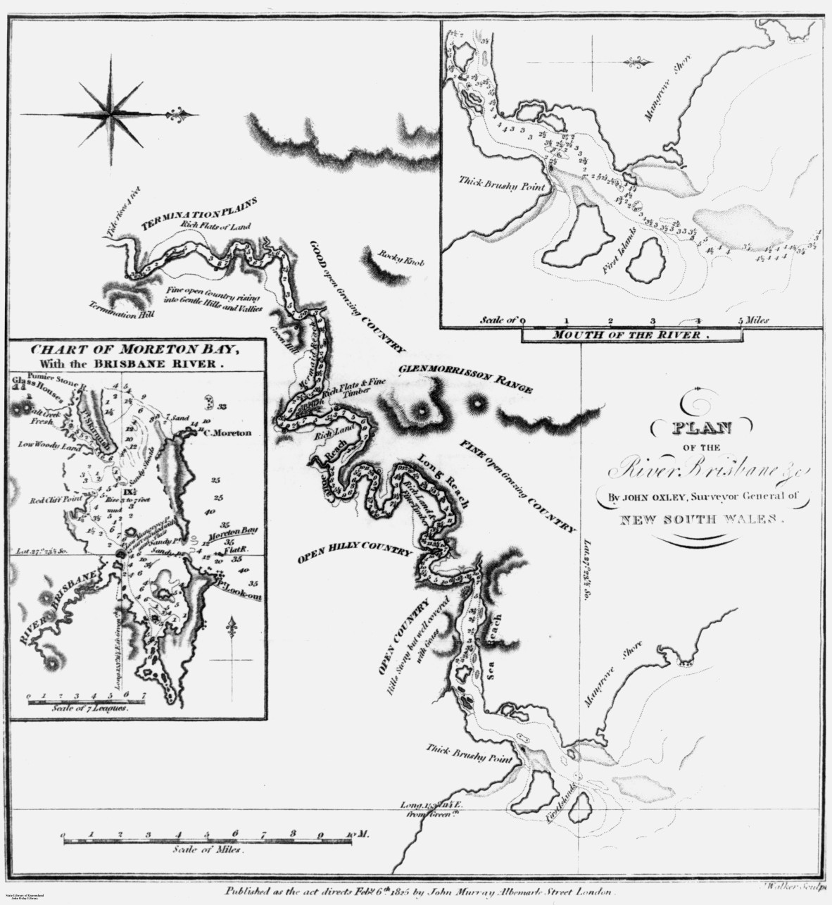
Plan of the River Brisbane and chart of Moreton Bay, as drawn by John Oxley, 1823. Negative no. 69012. John Oxley Library, State Library of Queensland.
John Oxley arrived in Moreton Bay on board the government brig, the Mermaid, on 29 November and immediately found two former convicts, Thomas Pamphlett and John Finnegan, who had survived a shipwreck and been cared for by local Aboriginal people. While Oxley suspected a large river entered Moreton Bay, Pamphlett and Finnegan confirmed they had been there.
![Landing of Oxley [work of art], 1851.](/sites/default/files/styles/slq_standard/public/Landing%20of%20Oxley%203.jpg?itok=Qutasn6D)
Landing of Oxley [work of art], 1851. A.G. Stark. Accession 30480 A.G. Stark Landing of Oxley [Work of Art]. John Oxley Library, State Library of Queensland.
On 1 December the small party set out aboard a small whale boat and entered the wrong river first. Oxley named it Deception River but it was later renamed the Pine River after the large numbers of hoop pines endemic to the area. After camping overnight nearby, they entered the much larger river the next day. It was known as Maiwar or Warrar to local Aboriginal people, but Oxley named it the Brisbane River after the Governor Sir Thomas Brisbane.
Oxley’s field note books are quite brief, mainly about surveying the breadth and depth of the river and picking out landmarks, but they do describe what he sees around him. We also have his Report of an Expedition to survey Port Curtis, Moreton Bay and Port Bowen, which Oxley wrote and presented to Governor Brisbane in January 1824.
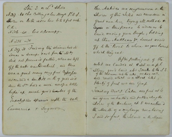
Extract from Field Book: Exploration of Brisbane River, 30 November 1823 – 5 December 1823. John Oxley (surveyor). Item ID: ITM291077. Queensland State Archives.
NOTE: right hand page contains the beginning of Oxley's entry for Tuesday 2 December 1823.
This is part of a series of blog articles covering John Oxley’s journey in Maiwar, the Brisbane River. On this day, 200 years ago, Oxley had camped the night at Shorncliff, close to the mouth of the Pine River (or ‘Deception River’ as he named it) after the ex-convict Finnegan had incorrectly led the party here in search of the large river suspected of emptying into Moreton Bay. They set off early, and soon found the entrance to a much larger river.
Oxley’s report states:
Early on the Second day (Decr. 2nd), in pursuing our examination, we had the Satisfaction to find the tide sweeping us up a considerable Inlet, opening between the first Mangrove Island and the Mainland. The muddiness and taste of the water, together with the abundance of fresh water Mollusca, assure us we were entering a large River, and a few hours ended our anxiety on that point by the water becoming perfectly fresh, while no diminution had taken place in the Size of the River, after passing what I have called “Sea Reach”.
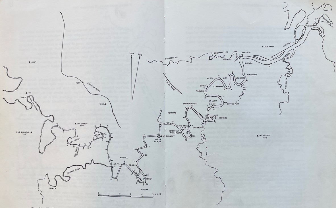
The Brisbane River according to modern surveys, showing Oxley’s routes in 1823 and 1824, figure 16 (p. 108-109), The Explorers of the Moreton Bay District 1770 – 1830, 1972. J.G. Steele. Published by University of Queensland Press. Call no. Q 919.432042 STE C2. John Oxley Library, State Library of Queensland
The map shown above, drawn correctly using modern surveys, charts Oxley’s routes up the river in 1823 and 1824. The numbered ‘stations’, where he took bearings and depth soundings, are referred to in his field notebook from 1823. The stations using letters are from his 1824 field notebook. Campsites are marked with a cross (X) and are dated. It should be noted reclamation works near the mouth of the river have caused significant changes since 1823.
Oxley’s field note book entry for Tuesday 2 December states:
Calm and fine at 6, we again embarked and pulled along the shores of the Harbour, about 8 we entered the Mouth of a very large river, having 3 and 4 fathoms, the Islands in the Main bay apparently closing up the Mouth of the River which between those Islands and the Main Land is about 2 miles wide. Proceeded up the River and at the end of the 1st Reach, having 4 fathoms, close to the Starboard [right] shore, landed to take bearings.
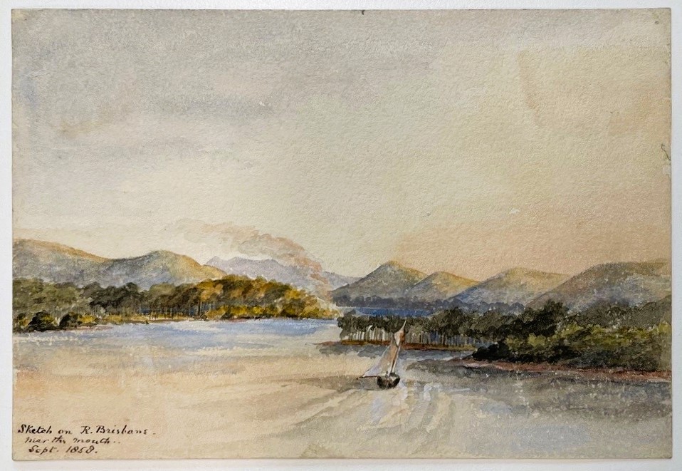
Sketch on River Brisbane, near the mouth, September 1858. Thomas Biddulph Hutton. Accession no. 30267 Thomas Biddulph Hutton watercolours. John Oxley Library, State Library of Queensland.
At the 2nd station he writes:
Ridge of stoney forest land, to this Station, the Larboard [left]. There has been a tolerable high ridge of Forest land, the Starboard side, low and swampy, the River widens in an elbow to pull ¾ [of a mile] wide, a good 3 fathoms channel.
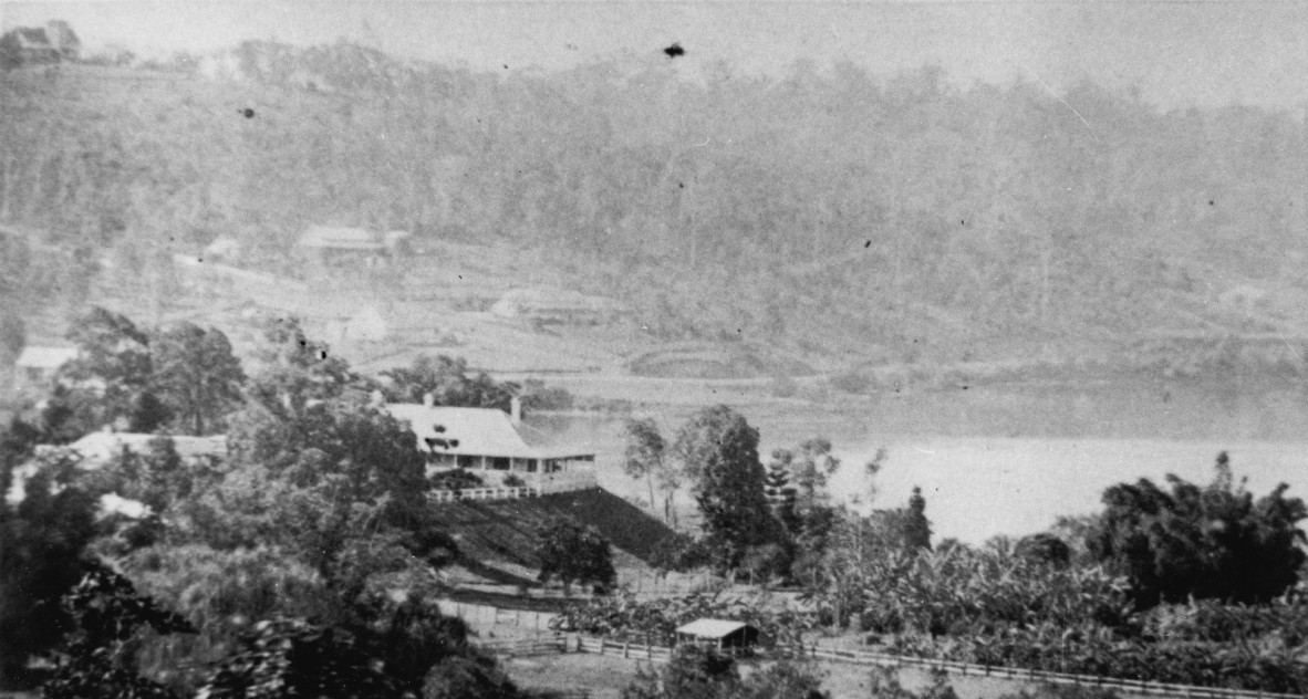
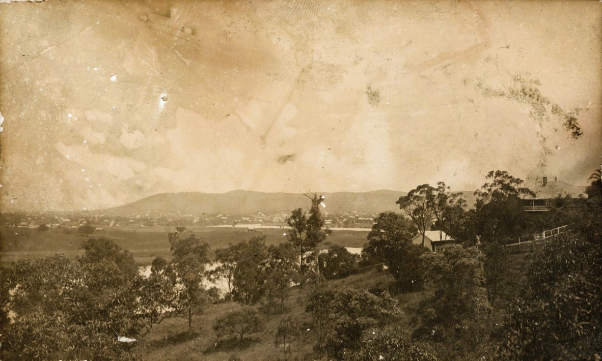
View of Brisbane River and Newstead House from O’Reilly’s Hill, Brisbane, ca.1872. Photographer unknown. Negative no. 108929. John Oxley Library, State Library of Queensland.
NOTE: O'Reilly's Hill was named after Captain O'Reilly, Queensland's first non-Indigenous astronomer, who built a large residence 'Montpelier' at what is now known as Bowen Hills.
The 3rd station, “on Rocky Point on Starboard Shore” is where Breakfast Creek enters the river. Oxley writes:
A small stream to Leeward…with the summit of high Mount on Larboard shore, the soundings to this station for 3 fathoms in the wide part to 10 fathoms in the Narrows. The River very beautiful.. Rock country and Timber good.
At station 5, located just past where Norman Creek joins the river, Oxley writes:
On Larboard shore [eastern side of Kangaroo Point], open forest land, soil sandy covered with Grass, Iron Bark Trees, good reach… The Bank of the River this side ends on a Forest Point. Opposite, low brush.
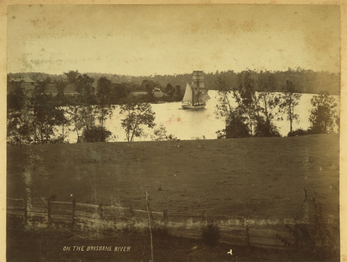
Sailing vessel on New Farm Reach, Brisbane River, ca.1860s. Photographer unknown. Image no. APO-026-0001-0003, from APO-26 Views of Queensland photograph album ca.1859-ca.1910. John Oxley Library, State Library of Queensland.
At station 6, located approximately where the Story Bridge reaches Fortitude Valley, he writes:
On Starboard shore landed on a high rocky Bluff. Opposite shore low and open Forest, covered with grass… Medium Breadth of River between 1/5 and 1/6 of a marine mile up to this point we have found navigable for ships of any size, the water nearly fresh… we dined at this Station and ascended the Bank in hopes of recognising some object on the Coast, but the Timber and Brush prevented us, we however discovered that we were not in the vicinity of any high land.
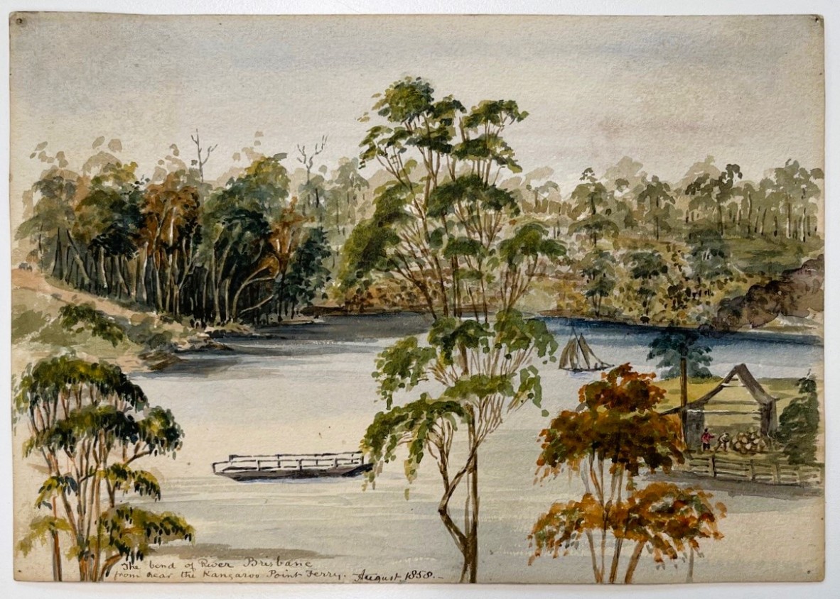
The bend of River Brisbane from near the Kangaroo Point Ferry, August 1858. Thomas Biddulph Hutton. Accession no. 30267 Thomas Biddulph Hutton watercolours. John Oxley Library, State Library of Queensland.
Oxley writes at station 8, located at the end of the Kangaroo Point cliffs, near the Maritime Museum:
At foot of high rocky Brush, opposite Starboard low and Brushy, next Station…to which opposite Forest Land…
Station 10 is located at North Quay, close to where a monument to Oxley was erected commemorating the 100th anniversary of him ‘discovering the site of this city’ on 28 September 1824. At this point, Oxley writes in his field notebook:
From this Station, to the next on the same Shore, the River forms a Magnificent crescent of 2 ½ miles of Forest Land… Shore a thick Brush with some Cypress [hoop pines].
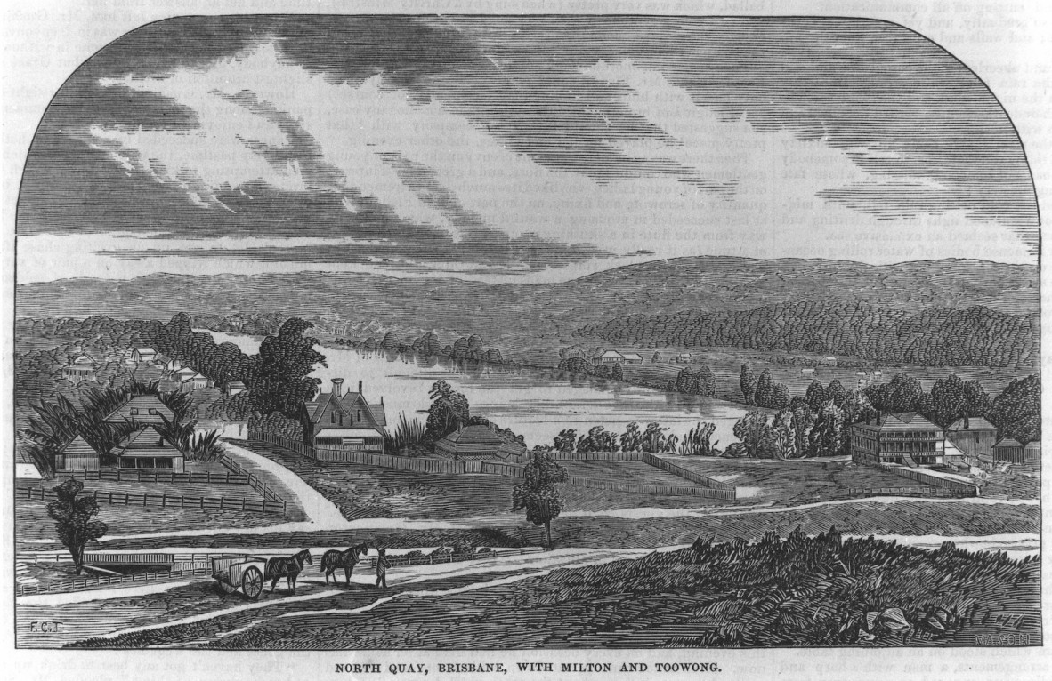
North Quay, Brisbane with Milton and Toowong, ca.1866. Engraving by F.C. Torry. Digital copy print, negative no. 143604. John Oxley Library, State Library of Queensland.
At station 11, Oxley writes:
On Starboard shore, which still continues low open forest, good Grass and Iron Bark Trees, opposite side rich low Brush.
Here, Oxley is describing the Milton and Toowong Reaches and both sides of the riverbank. A little further on at station 12, located at the start of St Lucia, he writes:
At this Station the low land on Starboard shore commences having Cypress intermingled with the Brush, the Next Station on Larboard shore… to a high rocky Bank, being the commencement of the high land on that side.
At this point, where Highgate Hill meets Dutton Park, Oxley reiterates the ‘high rocky land’ and mentions ‘thick Brush’ on the opposite shore which is the site of the University of Queensland’s St Lucia campus.
For the final station on this day, station 14, Oxley writes:
…Brush on both shores with Cypresses. At ½ past 6, landed at the Termination of the Brush on Starboard [St Lucia] shore on a piece of Forest land. River quite fresh, low water, the tide has a rise of at least 5 feet and up this point a distance of 20 miles, the River is navigable, for vessels of any Burthen (a Rock midway in River).
Looking across the river to St Lucia from Dutton Park, ca.1920. Photographer unknown. Negative no. 197152. John Oxley Library, State Library of Queensland.
Of his first full day in the river, Oxley writes in his report to the Governor:
Our progress up the river was necessarily retarded by the Necessity we were under of making a running Survey during our passage. At Sunset we had proceeded about 20 miles by the River; the Scenery was peculiarly beautiful; the country on the Banks alternately hilly and level, but not flooded; the Soil of the finest description of Brushwood land, on which grew Timber of great magnitude, and of various Species, some of which were unknown to us, among others a magnificent Species of Pine [by now, Oxley had correctly identified the Cypress as a pine] was in great abundance. The Timber on the hills was also good, and to the S.E. a little distance from the River were several brushes or forests of the Cupressus Australis [Bribie Island pine] of very large size.
In the next blog article, we continue to follow John Oxley on his voyage up Meanjin, the Brisbane River. There will be a blog article for each day of his journey exactly 200 years ago, from 2 December when he entered the river to 5 December when he returned to his ship, the Mermaid, in Moreton Bay.
Further resources:
Accession 33036 John Oxley papers
Report of an expedition to survey Port Curtis, Moreton Bay and Port Bowen: with a view to form convict penal settlements there, 1825. John Oxley. Call no. RBJ 994.3 OXL. John Oxley Library, State Library of Queensland.
Plan of the river Brisbane by John Oxley, Surveyor General of New South Wales, created 6 Feb. 1825. John Oxley; John Walker sculpt. Call no. RBM 841.15 1825 00265 E. John Oxley Library, State Library of Queensland.
The Explorers of the Moreton Bay District 1770 – 1830, 1972, by J.G. Steele. Published by University of Queensland Press. Call no.Q919.432042 STE C2. John Oxley Library, State Library of Queensland.
Field Book: Exploration of Brisbane River, 30 November 1823 – 5 December 1823. John Oxley (surveyor). Item ID: ITM291077. Queensland State Archives.
Comments
Your email address will not be published.
We welcome relevant, respectful comments.