Guest blogger: Mark Clayton
Like other eminent organisations, Qantas too has its own foundation narrative – concerning two recently demobbed Australian airmen (Hudson Fysh and Paul McGinness) who, in an epic 2,180 km overland journey in Model T Ford, successfully surveyed the continent’s northern aerial route from Longreach (Queensland) to the Katherine River (Northern Territory) railhead in preparation for the first England to Australia Air race arrivals.
For fifty-one days they endured privation and unimagined challenges, such that ‘Every mile they bumped over the bush trails’ only further ‘emphasised [for them] the advantages of an outback air service’. [2] .Within eighteen months they had generated enough interest and capital to register a company (known initially as the Western Queensland Auto Aerial Service Ltd.), and on 3 November 1922 pilot Hudson Fysh inaugurated its first fare-paying scheduled passenger service between Longreach and Cloncurry.
By retracing that inaugural route I’d hoped to gain some added insight to what those first Qantas passengers and pilots must have experienced, my two-seat 1930s-era tail-wheel aircraft lending some authenticity to the venture.
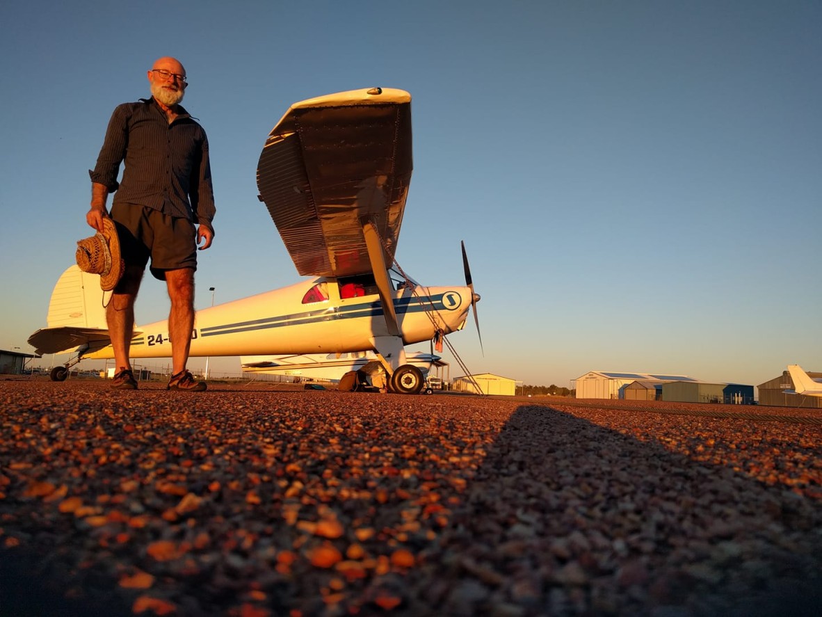
Mark Clayton and his 1930s-era Luscombe Silvaire, coloured by a Longreach sunset. Although dimensionally comparable, and with similar engine power outputs, my all-metal monoplane is noticeably lighter (by 163 kg) and faster (15 knots) than the wood and fabric Avro 504 biplane used on those first Qantas services. Photo courtesy of Mark Clayton.
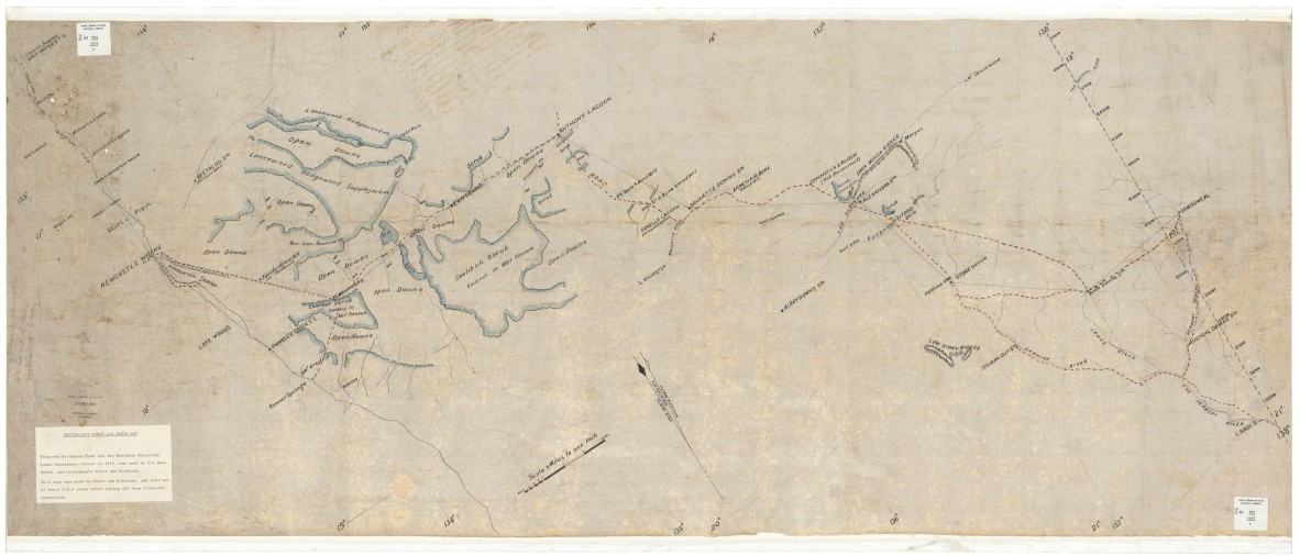
The first Australian aeronautical chart, drawn by Paul McGinness during his epic overland survey in late 1919. State Library of New South Wales collection
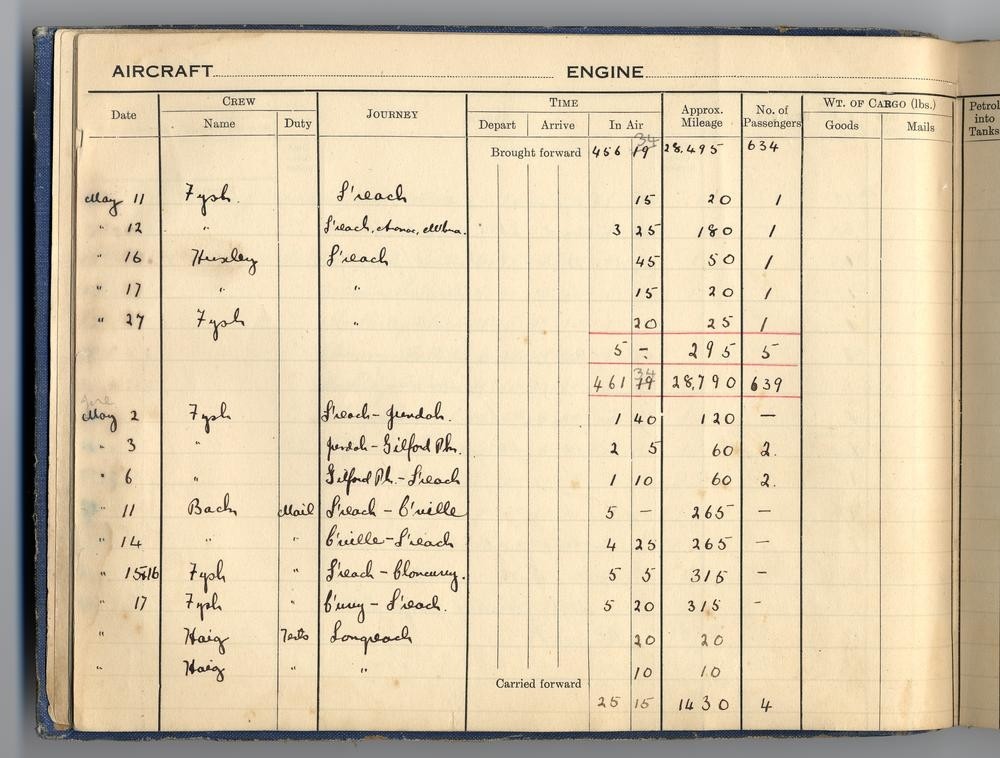
Now considered a national treasure, the logbook of the first Qantas aircraft records that on 17 May 1921 Hudson Fysh took 5 hours 20 minutes to complete the 315 miles from Cloncurry to Longreach (sans passengers), the Avro 504 having carried a total of 643 passengers by then. 4117, QANTAS Log Book, John Oxley Library, State Library of Queensland.
I picked up the Qantas route at Camooweal near the Queensland-Northern Territory border, my westward progress along the Australian coastline having been thwarted by an unexpected loss of network coverage (necessary these days for lodging mandatory flight plans and obtaining meteorological updates). Although never part of the airline’s initial service Qantas’s first Directors were, by early 1924, actively seeking ‘an extension of the present service from Cloncurry to the new Mt. Isa silver-lead field and on to Camooweal, the front door of the Northern Territory.’ By the following decade this would form part of the Kangaroo Route, a name (and now a Qantas trademark) used to describe the airline’s Sydney-London service via the eastern hemisphere.
Still a tiny grid of streets (established alongside the optimistically named Lake Francis), Camooweal appears to have diminished with the passing of the years. Whereas there was once a substantial Qantas hangar at the airstrip, fashioned from rough-hewn tree trunks, there is now nothing to be seen - other than a Bunning’s flat-pack tool shed. Gone too are the cross runways that were once to be found at every Qantas port-of-call, including Charleville, Longreach, and Cloncurry. These allowed pilots to put down more-or-less into wind at every destination, thereby minimising the dangers associated with landing in gusty, cross-wind conditions. Only the overgrown outline of these intersecting runways remain today, most municipal councils these days being unable to afford maintaining more than one.
I stay just long enough to decant another five gallons of motor spirit into my wing tanks - as those first airline pilots would have done - thankful for the sealed bitumen runway and the rare absence of the now overbearing perimeter security which, since 9/11, has become a permanent feature at all RPT (regular public transport) airstrips throughout Australia, regardless of their size or remoteness. Even though it’s late Autumn the temperatures at ground level are witheringly hot, making for a long and bumpy climb up to my cruise altitude of 3,500 feel (above sea level) where I am afforded some relief from the continually rising and falling convection thermals. Any higher and I risk being further slowed by the howling south-easterly winds that have been blowing for a fortnight across the eastern states.
Where normally I could plan for an 80 knot (142 kms) cruise speed, my average speed across the Barkley Tablelands, on this occasion, is just 55 knots. The first Q.A.N.T.A.S. services would for these reasons take to the air long before the sun had risen, thereby avoiding the worst of the day’s headwinds and turbulence (their normally aspirated engines also delivering better climb performance in the cooler, denser, morning air). In September 1926 a first-time passenger (J.O., N.Q.), published a detailed account of flying this same route - albeit, in reverse - with Qantas:
‘The climb out of the ‘drome was steep. In the first curve we cleared the trees, and tracing a nobly expanding helix in the third, we were ready to sail over the mountains. Your first ride in the air is thrilling, but, when you are well up for your second, the whole thing begins to seem so obvious that you wonder how other modes of locomotion, in such a country, ever contented you. After 75 miles we were over Yelvertoft, at 5000 feet. Mr Evans then let her right out for Camooweal, sweeping down the 50 miles in one slant. The propellor, he told me, was doing 1500 revolutions, and we covered that 50 miles in 27 minutes. In September 1914, Boultbee and I rode all night, camping only from 10 to 11 p.m., and from 4 to 6.30 a.m., and got into Camooweal at 11 a.m., after 18 hours on the track…’
(Townsville Daily Bulletin, 6 September 1926, p.10).
Then as now, pilots try to maintain a constant heading by using a magnetic compass, an ancient device that can be difficult to stabilise on hot days when the air is filled with invisible thermals. Navigating from Camooweal to Mount Isa however also involves keeping the Barkley Highway visible on your left (its course having scarcely altered in the past century). Never more than 10 nautical miles (17 kms) to port, it is bisected by the Buckley River which, though more-often dry, carves a very distinctive course easily discerned from an overflying aircraft. As the only habitation along this route Yelvertoft Station – also halfway, and easily spotted – has long served as an emergency landing ground and navigational reference point especially for trans-continental pilots.
‘The portion of the route between Carlton [sic] Hills’ letter box and Camooweal entails a flown distance of 96 miles, and the country traversed is good from a flying point of view, open spaces being frequently met with and open downs round Yelvertoft Station.’
(Longreach Leader, 17 April 1924, p.18)
From the vantage of an overflying aircraft this western landscape appears unchanged from what those first airline passengers and pilots must have seen, almost a century earlier. Nearing Mount Isa however I can discern the mine stacks and the unnaturally large form of Lake Moondarra, the realities of the twenty-first century only fully intruding after I have shut-down my engine and stepped onto the apron. Even though it is Sunday afternoon, with no other traffic seen or heard, I am immediately challenged by the duty ARO (Airport Reporting Officer) demanding to see my ASIC (Aviation Security Identification Card). Of course he is just doing his job, and before driving off with his amber lights flashing he reminds me that it is mandatory for anyone airside at Mount Isa, for obscure health and safety reasons, to also wear a high-visibility shirt or jacket. Alone, yet surrounded by surveillance cameras, I elect to forego the restroom stop and press on for Cloncurry.
‘We kept curving northward, making for Mount Isa, whose range is silver to the heart. We had been an hour and a quarter on the wing when I was aware of the sensations that accompany a rapid descent in an express lift from the twelfth floor, again a queer pressure on the ears, for which you must swallow repeatedly. The trees were growing again, and scudding between them I saw a small brown moth, which was our shadow. A flashing rectangle the size of a playing card was the roof of the Mount Isa Hotel. We were circling, and to do this the Pilot ‘banks,’ that is, he deflects the ailerons (narrow flaps at the ends of the planes on their hinder side). The right wing with raised aileron dipped, the left with lowered aileron tilted upwards. So, we could swerve without ‘skidding.’
The trees were growing fast, and we threw the shadow of a great eagle. But where were we going to land? I could see no open space, only trees. Another swoop and the little bald patch of the aerodrome rose to meet us, and there was the white ground circle and the sausage which shows the direction of the wind. We swept and curved down steeply, got into the straight, skimmed and then made what the Pilot called a pancake landing. He raised the horizontal rudders in the tall, and that threw up Gauff’s [sic] nose and she flounced against a wave of air, gave herself a toss and almost immediately her wheels were on the earth. The sensation of landing is very like that which you get when your boat grounds and her nose runs into the shingle. The Mount Isa ‘drome is small. We raced over its still rather scrubby surface, swung to the left about 70 yards from the fence, and went off again down the straight. There is a spike under the tail of the machine which acts as a brake, cutting a furrow two or three inches deep in the ground, and the drag of that soon pulls you up. The landing here was a short one. A car came out to get our mails, we got the news of Mount Isa, and were off again in twenty-five minutes.’
(Townsville Daily Bulletin, 6 September 1926, p.10)
At just 57 nautical miles (kms) the leg from Mount Isa to Cloncurry was both the shortest, and most nerve wracking – the rugged mountainous terrain here simply presenting no opportunities for a safe forced landing (in the event of an engine failure). Although mesmerizing from above this region, which geologists refer to as the Mount Isa Inlier, comprizes ‘prominent ridges of quaruite, acid volcanics and silicified fault zones [with] separate undulating valleys underlain by shale, schist, calc-silicates, basic meta-volcanics, and granite.’ [4]
Over such a short course with the highway never more than 9 nautical miles (17 kms) to the south; and with Cloncurry almost due east of Mount Isa; navigating between the two points shouldn’t be difficult – only it can be. It all looks the same from overhead, the tortured geological forms below allowing only fleeting, occasional glimpses of the highway. It was for this reason, perhaps, that the first Qantas flights tended to follow the railway line south to Duchess, then north-east (via Malbon) back into Cloncurry, a circuitous detour that almost doubles the flight time. Thirty kilometres east of Mt Isa I pass over the headwaters of the Leichhardt River – which empties into the Gulf of Carpentaria – looking just like every other dry creek bed in these parts, its waters having been dammed in the late 1950s to provide water for the now-abandoned Mary Kathleen uranium mine township.
‘I got into the cabin. It was built for persons not exceeding 5ft. 6in. in stature, whereas I .. .. .. but let that pass. The pilot gave me a fine leather cap and I am glad to say I had brought thick rugs. They shut the lid of the cabin, which made it necessary for me to sit lower, and left slits of windows, 18 inches deep on each side. And now comes the moment which makes you feel you have not lived in vain. The chocks are kicked away from the wheels and Gauff moves forward, gathering speed, swings in a half circle, and heads into the wind. She is seen racing along the plain at 40, and then at 50 miles p.h. You await levitation with the same kind of eagerness which fascinated you when your beautiful toy engine of early youth began to function under steam. Gauff roars with frantic impatience to get away from the apron strings of mother earth, she frets to spurn the ground, tugging with fierce annoyance against the grasp of Great Aunt Gravity. It is not easy to tell precisely when you leave the earth, the character of the vibrations does not change suddenly, but, looking over the edge of the cabin sill, you notice that the height of the wings above the ground is a little more than it was, and the movements steadying. Once you have risen clear the roar of the engine increases to its maximum, the speed of the ‘plane becomes 90 miles p.h., and the space between the wings and the earth opens out with delightful rapidity. You swim in space. You rise spirally. The first curve over the aerodrome carries you to 300 feet, and after that you climb into the sky at a great rate. The huge hangar is soon no more than a humpie. A second wide sweeping curve and Cloncurry, when I looked at it from 1500 feet, had become as a few rows of dominoes laid out on the brown plain. Soon we were on our course and heading S.W., skirting the Argylla Ranges. The Cloncurry River had become a devious ditch wandering between two rows of cabbages, which had once been trees. Two thousand, three thousand, four thousand feet, up we go. At 5000 feet the trees have become dandelions, and houses are no more than dice dropped on a red brown table cloth. The earth appears not round nor flat, but saucering slightly, through, refraction, towards the horizon, which is now a hundred miles away. Sitting in the 32in. wide cabin, at first you hesitate to move for fear of disturbing the balance of your slender craft. It reminded me of my first attempt in a racing sculler (‘phunnies’ we used to call them, elsewhere they are called ‘whiffs’). The least mistake at first sent you into the water, but presently you learned to move without endangering your balance. So, too, in a ‘plane. The pilot told me afterwards that he could feel every movement of a passenger. The ‘plane gives to it if you only lean forward to look out of the cabin window.’
(Townsville Daily Bulletin, 6 September 1926, p.10)
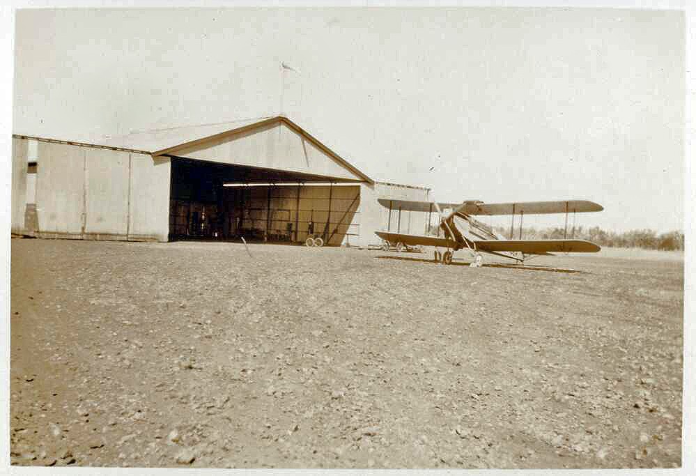
De Havilland DH50A G-AUER outside the Qantas hangar at Cloncurry. With its enclosed cabin accommodating four passengers, the DH50A marked the end of the cap and goggles era for passengers. National Library of Australia collection.
Like Longreach, Cloncurry has for a hundred years enjoyed unbroken prosperity as an inland aerial terminus assisted mid-century by wartime expansions and, more recently, by tourism and mining FIFO operations. Original (and identical) Qantas hangars are preserved at both centres, each proudly showcasing its connection with the national carrier. Unlike Longreach however, Cloncurry’s airport is some 4.2 kilometres north of the town, leaving me to wonder just how enthusiastic crowds were ever able to assemble there – often at short notice – for those first aerial arrivals? While geography might have limited Paul McGinness’s airport siting options at Cloncurry, the same restrictions are not evident at Winton where the airfield and township, both sited on an expansive flat plain, are inconveniently – and inexplicably – 5.5 kilometres apart.
At 177 nautical miles (328 kms) the flight between Cloncurry and Winton, with its intermediate fuel stop at McKinlay, was a comparatively long haul offering few scenic distractions during the usually prolonged dry months.
Though clearly enraptured, Qantas’s first fare-paying passenger (84 year old grazier Alexander Kennedy) was at pains nonetheless to disguise the harsh realities of what he had seen and experienced…
‘At present the [fuselage cabin] space is small, and the noise from the engine is a little disagreeable…In travelling our distance from the ground was about 4000 yards [sic], and as the day was hazy, we could see but little on the ground. A fence could be seen now and then, and I regret to say that all the country from Barcaldine to here is still in need of rain. I have not seen green grass since crossing the Drummond Range in the train, and all the stock seen were in low condition.’
(Daily Mail, 11 November 1922, p.12)
That inaugural fare-paying service averaged what would have then been a respectable 60 knots (111 km h), assisted – in one direction at least – by the prevailing winds. Although the land was parched in early November 1922, the many channels that form the headwaters of the ephemeral Diamantina River would have been easy to distinguish, the Thomson River’s unmistakeable form having also served as a beacon – on more than a few occasions – for Qantas pilots who’d lost their way to Longreach.
Back then passenger and pilot would have communicated using sign language and scrawled notes, there being no intercom or air-to-ground electronic communications. By contrast, the wizardry of my ANR (Active Noise Reduction) headset allows me to converse effortlessly, guided by multiple GPS devices that bombard me with more navigational, meteorological and communications data than I am able to assimilate. And if my engine did suddenly stop out here in the boondocks I could, simply by switching radio frequency, communicate my distress immediately to the Brisbane Flight Information Service (or any other traffic in the area). Once activated, my EPIRB (Emergency Position Indicating Radio Beacon) would also allow the Australian Maritime Safety Authority – in Canberra – to quickly pinpoint my location and initiate local reach and recovery operations.
The temperamental telegraph was the only form of electronic communication available when Qantas began its airline service in late November 1922. A plane’s expected time of arrival would be transmitted to the point of destination whereafter, there was a total information blackout between departure and arrival.
Aside from these wondrous technological advances I am struck, mostly, by how little the landscape and aerial journey along this historic route have changed during the past century. Although the earth appeared unnaturally green (a consequence of the flooding that devastated western Queensland in early 2019), the land here remains just as vast, uninhabited and captivating as it much have seemed to those first aeronauts. And although there were dozens of international flights overflying me (at 30,000 plus feet) I never once, down low, encountered or heard another aircraft at any point between Camooweal and Longreach. It might just as well have been early November 1922.
Mark Clayton
References
-
Title of article, “never…except by aeroplane” from The Daily Mail, 6 Nov 1922, p.9
-
Cilento, R. ‘An Idea Whose Time Has Come: Australia’s Destiny as Bastion of South-West Pacific’, RHSQ Journal, Vol.7 No.2 (1963), pp.231-232.
-
‘Aviation’, The Longreach Leader, 17 Apr 1924 , p.18
-
Whitacker, W.G. Mt Isa Field Conference, (Geological Society of Australia, 1975), p.6
Further reading from Mark Clayton
Comments
Your email address will not be published.
We welcome relevant, respectful comments.