Putting your block of land in context by using maps
By Christina Ealing-Godbold, Research Librarian, Information Services | 10 August 2020
Land – putting your block of land in context by using maps.
Understanding the history of the land upon which your house is built begins the story. Land has its own story of subdivision and ownership through transfers, inheritance and sales. Learn how your piece of land fits into the land division in that suburb and estate. The creation of estates with names suggesting freedom, independence, and a better life led earlier generations to secure that piece of land to build their home. What promises were made for the buyers of your land when it was first available for sale?
Maps at the State Library of Queensland
The State Library of Queensland holds many different kinds of maps that are useful for learning about the history of your land – cadastral, estate, sewerage – these all reveal something of the land on which your house exists.
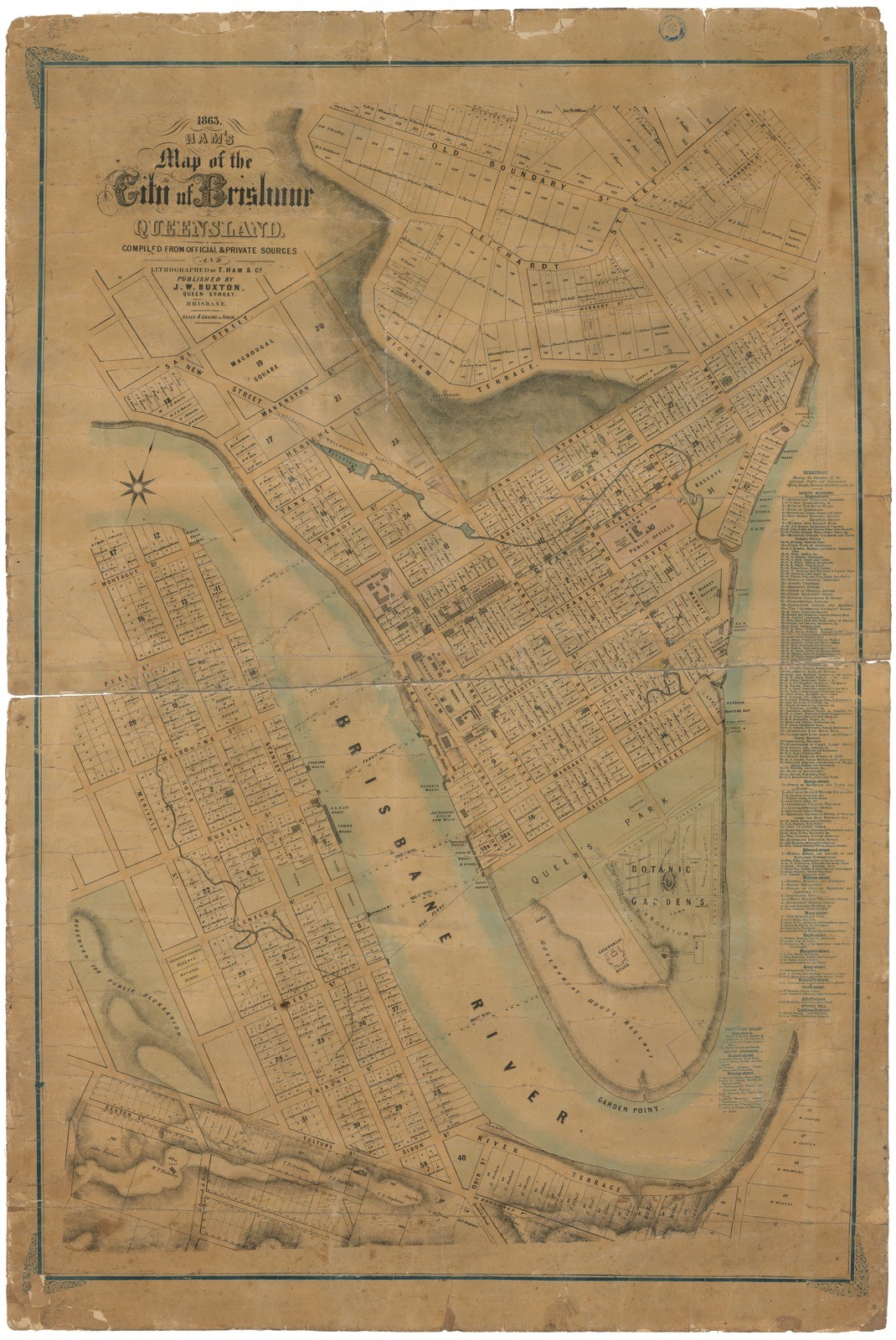
Maps such as the Brisbane Water and Sewerage Maps of 1917 show the overview of suburbs and subdivisions; the McKellar maps (more on these below) show portion numbers and subdivisions in Brisbane prior to 1900 and older maps such as Ham’s Map of Brisbane, Queensland (1864) illustrate earlier concepts of areas, streets and features such as water supply and cemeteries.
Maps can also provide original street names and connecting roads between estates and suburbs. Portion numbers are important for later searching in newspaper indexes and this can be seen on the McKellar ‘6 Chain’ series 1895 (cadastral) maps now available at the Queensland Data Portal in digital form.
John Oxley Library has the Maps of Brisbane and Suburbs 1917 in a bound volume in the reading room on Level 4, as well as the McKellar maps in paper form. Ham’s 1864 Map of Brisbane is also available as a poster at the Library Shop. Read more about this map in our previous ‘map of the week’ blog.
Estate Maps
The most interesting maps for your house history are the Estate Maps. Estate maps show the way the land was sold and the promises made by agents about the nature of the land - beautiful views, healthy breezes and the like.
Auctioneers and real estate companies such as Cameron Bros, Henzell, Blocksidge & Ferguson and Isles Love among others, kept archives of their estate maps, many of which fortunately made their way into the John Oxley collections.
Not only do the estate maps demonstrate the original arrangement of the blocks of land in the estate but in addition, they often show nearby landmarks, estates or larger houses that may help place the estate in context. This can assist in providing information about the early land use patterns of your suburb. Estate maps are also colourful, and often show the inducements that were offered to prospective buyers to come to the land sale or auction, including lunch and entertainment. It was not uncommon for free buses, trams or trains to also be provided to those who wished to attend the sale.
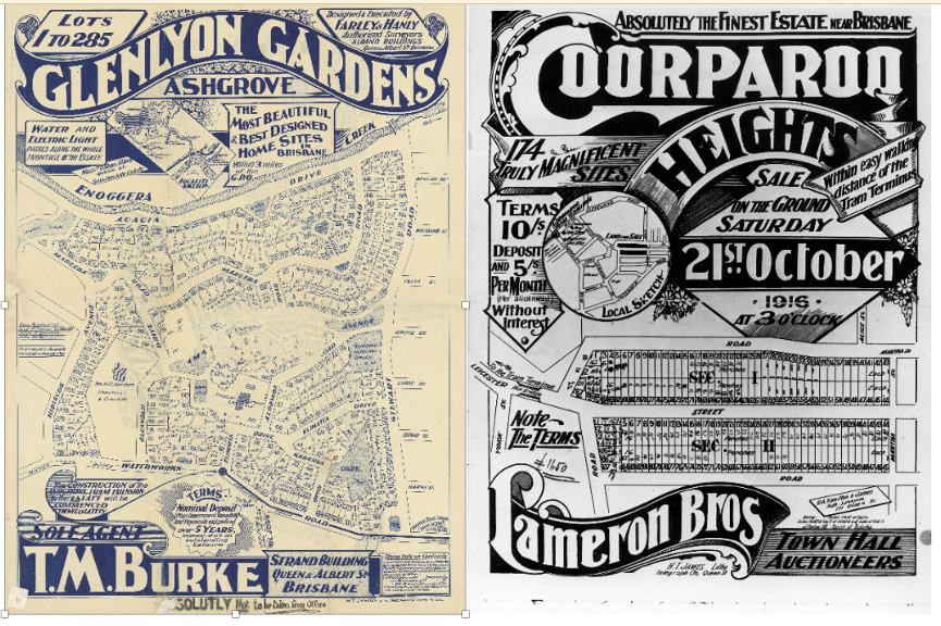
Available in glorious colour, these estate maps have now been digitised and can be found in and downloaded from the State Library of Queensland’s One Search catalogue. We also have many of these vintage maps for sale in the Library Shop.
Brisbane City Archives - Detail Plans
State Library of Queensland works closely with other archives in Queensland, including the Brisbane City archives. Included in their collections are additional maps and plans that can be useful for your house history.
One kind of map held by the Brisbane City Archives that is very useful for researching the history of your house is the ‘Detail Plan’ – a plan that was surveyed for the purposes of water and sewerage but also shows the topography. Dating from 1911- 1950s, they show the exact street and blocks of land. Unlike the estate maps, the Detail Plans are black and white line drawings, signed and dated by a surveyor. The plans were working documents, so new houses could sometimes be added after the original survey date.
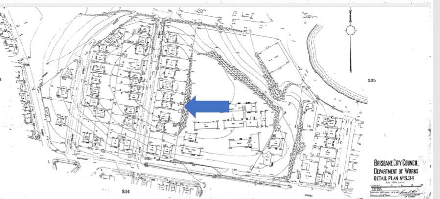
The plans show the footprint of the house on the block of land, including veranda and stair placement, sheds and outbuildings. This reveals how the house may have changed over time – especially useful if you are renovating. House names are often used on these plans and this can be a welcome gift for those researching the history of the house. Detail plans show vacant blocks and easements that later became streets which can help ensure that the correct block and placement in the street is understood.
To access a Detail plan, you will need to check the Brisbane City Archives website and search the indexes for the plan number. This requires attention to detail to ensure you have the correct plan number. However, once located, the detail plan is invaluable for your house history.
The Brisbane City Archives also hold Surveyors’ Field Notebooks which can be used in conjunction with the plans.
Museum of Mapping and Surveying
State Library also works closely with the Museum of Lands Mapping and Surveying, now located in Edward Street in Brisbane. The Museum has digitised many maps that are important to the history of Queensland, including cadastral maps that show boundaries and ownership of land. There are many map series, including the McKellar series of 1895 , available at the Open Data site. State Library staff can assist you in researching the collections of the Museum of Lands Mapping and Surveying.
QImagery
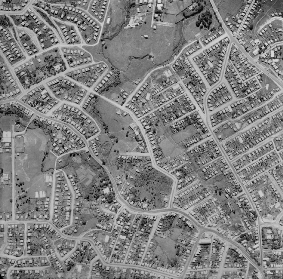
The Queensland Government has another wonderful resource for house histories called QImagery which includes aerial images of Queensland land, from the earliest aerial photographs through to 2002. Searchable via address or by map, the QImagery site provides a literal bird’s eye view of the land use patterns of our state, and by zooming in on the photograph, you may be able to see if your house was located on the land at the date of the ‘fly over’.
Most popular at QImagery are the maps of the Brisbane area 1946 -1951, allowing home owners to see if their home existed by the end of WW2, and useful for the outer suburbs where historical information may be scant.
There are so many kinds of maps, all offering additional information about lands in Queensland. Maps of parishes, counties and pastoral runs can also be useful for your house or property history.
Discover how natural land formation and topography may have been modified for land use over time – how the higher side of a street was eventually made available for land sales via terraforming. Finding out how lands were carved out of the bush, and bridges built to ford waterways, can assist in understanding how the town, locality or suburb developed.
Maps are an invaluable source of information when researching your home or property. State Library has access to maps of all kinds, and our staff can assist in finding the most relevant map for your research.
Visit State Library’s house histories webpage and ensure you know the range of resources that are available for your search. Staff at State Library will help you navigate through these resources and provide suggestions for further research.
Once you have established the physical context of your house on its block of land, the next clue to its age will be its architectural features. Come back soon to read the next blog in this series, The Queenslander House - Architectural Features.
#HouseHistoryBlogSeries
[This is blog no. 2 of 5 in the House Histories Blog Series]
More information
House histories - /research-collections/queensland/built-heritage/house-histories
Corley Explorer - https://explorer.corley.slq.qld.gov.au/
One Search - http://onesearch.slq.qld.gov.au/
Ask us - /plan-my-visit/services/ask-us
Comments
Your email address will not be published.
We welcome relevant, respectful comments.